Fuels
Fuels
Hydrocarbons
Reservoir Rocks
Seals
Traps
Oil and Gas Exploration
Seismic Surveying
Exploration Drilling
Well Evaluation
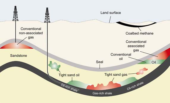
Oil Sands
Gas Hydrates
Oil Shale Fracking
see also Oil Exploration...
see also Refining Petroleum...
see also Offshore Oil Drilling...
see also oil Spills...
see also Oil Deposits...
source: http://www.open.edu/openlearncreate/mod/page/view.php?id=41010
Hydrocarbons
Fuels contain long chain carbon atoms for example octane has 8 carbon atom and is the main hydrocarbon in petrol (gasoline)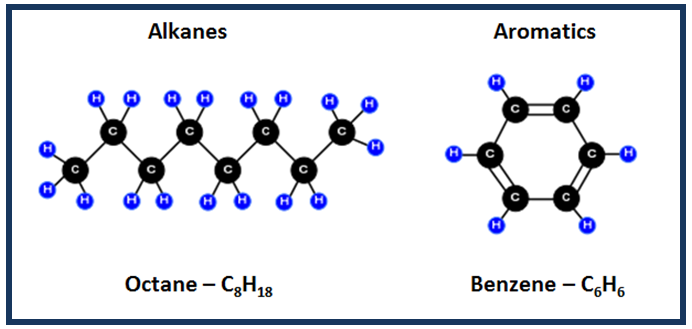
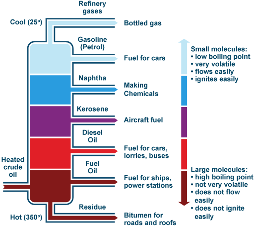
Crude oil refers to hydrocarbon mixtures produced from underground reservoirs that are liquid at normal atmospheric pressure and temperature.
Natural gas refers to hydrocarbon mixtures that are gaseous, at normal atmospheric pressure and temperature – the gas mixtures consist largely of methane – the smallest natural hydrocarbon molecule (CH4).
The extremely variable compositional complexity of petroleum reveals the joint effects of all processes involved in the origin of petroleum accumulations and their history during the geological time.
Hydrocarbon reservoirs (porous and permeable host rocks) are thousands of feet below the surface, and oil and gas accumulations form in sedimentary basins if the some geological conditions (Petroleum System) are met:
- Existence of source rocks which generate petroleum under particular subsurface temperature conditions
- Expulsion of petroleum from the source and subsequent migration
- Occurrence of reservoir rocks of sufficient porosity and permeability allowing flow of petroleum through the pore system
- Configurations and arrangement of rock layers to form traps
- Presence of impermeable layers (cap rocks) to confine petroleum accumulations in place
- Correct timing with respect to the sequence by which all the above processes have occurred during the history of a sedimentary basin
- Advantageous conditions for the preservation of petroleum accumulation during the geologic time
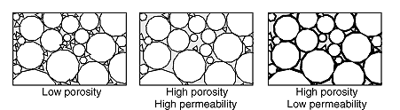
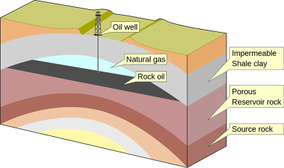
Reservoir rocks
The properties of a petroleum reservoir rock are very similar to those of an aquifer since both petroleum and water can be contained within and move between its pore spaces and fractures. Sedimentary rocks that are well cemented have only small voids between grains and hence low porosity.The essential properties that describe a reservoir rock are porosity (the void space expressed as a percentage) and permeability (a measure of the degree to which fluid passes through it, measured in millidarcies, mD).
Seals
Above permeable reservoir rocks there must be an impermeable layer (known as a seal or cap rock) to stop migrating petroleum from rising further towards the surface of the Earth. Seals are fine-grained or crystalline, low-permeability rocks such as mudstone, anhydrite and salt. Rock salt is by far the most effective seal, because it is crystalline and therefore impermeable. Seals are also enhanced if they are ductile (ductile deformation prevents the formation of open fractures and joints), substantially thick and laterally continuous; little surprise then that the largest oil fields in the Middle East are sealed by evaporites (Argles, 2005) with these characteristics. However, seals are rarely, if ever, perfect. Hydrocarbons can migrate through almost all rock types, but at different rates that depend upon any fracturing and microscale fluid flow, and whether liquids adhere to or are repelled by the surfaces of mineral grains. Many oil and gas fields have active surface seeps of petroleum overlying them that provide a direct indication as to their location. In marine settings seeps may be detected as bubbles of gas rising from the sea bed, or as an oily sheen on the water. On land, plant communities are stunted, surface layers of rock and soil may be altered, tarry residues may encrust the surface, and sometimes there may be active oil seeps. The first oil fields to be developed in the 19th century were located beneath such obvious features. It is thought that ignition (by lightning strikes) of petroleum escaping above the huge oilfields of Iran gave rise to the fire-worshipping Zoroastrian religion. Even odder, the Ancient Greek Oracle at Delphi is thought to have made her prognostications while hallucinating under the influence of escaping natural petroleum gas.Traps
Petroleum that accumulated as a thin layer at the top of an extensive horizontal reservoir would be uneconomic to extract. That is because many wells, each with only a small rate of production and lifetime, would be needed to extract the petroleum. To be worth working, a sealed petroleum-bearing ‘container’ or trap must be shaped naturally to retain and focus petroleum, rather as the curved upper surface of a balloon traps buoyant hot air. The lower surface of a trap is defined either by a petroleum–water contact or sometimes by another seal. There are many different styles of trap but the most common are structural traps in the form of anticlines produced by tectonic processes, by differential compaction of soft rocks above hard, irregular surfaces and by evaporitic salt masses that rise gravitationally. The low density of salt, combined with its ductility, enables it to rise to form domes and intrusive masses. Because they produce distinctive geological and geophysical features, structural traps are the easiest to find.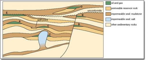
A–C are structural traps, D is a stratigraphic trap and E is a combination trap.
About 80% of the world's petroleum reserves are held in structural traps like those shown They include:
Structural Traps
- simple anticlines (A),
- faulted structures that juxtapose reservoirs against seals (B),
- and traps created at the flank of a salt dome or in compaction anticline above it (c)
- result from lateral changes in rock type and typically consist of discontinuous sandstone bodies encased in mudstone (D) Sometimes referred to as ‘subtle traps’, they currently contain about 13% of the world's petroleum reserves, but much of the remaining undiscovered petroleum will probably be found in these settings because the more obvious structural traps have long since been exploited. In practice, traps often form through a sequence of different processes over the course of tens of millions of years.
- For example, in E the reservoir was first deposited, then folded, uplifted and eroded, before being overlain by a much younger impermeable mudstone. The resulting configuration is appropriately called a combination trap. Provided it was intact before the reservoir received a petroleum charge, it forms a valid trap regardless of how long it took to form.
- As petroleum accumulation continues it is possible for traps to fill beyond their natural spill-point, when petroleum can escape sideways to re-migrate to other traps (upper C) or to the Earth's surface where it emerges as oil or gas seeps
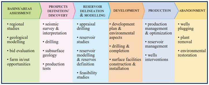
Oil and Gas Exploration
Exploration Cycle:
Seismic Surveying
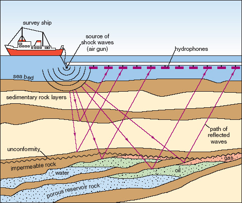
Seismic surveying is by far the most widely used and important method of gaining an impression of the subsurface. Seismic surveys can be acquired at sea as well as on land. The marine method is the most common in petroleum exploration and is shown schematically in although the same principles apply to any seismic reflection survey. Marine seismic acquisition; pulses of sound energy penetrate the subsurface and are reflected back towards the hydrophones from rock interfaces.
Compressed air guns towed behind a boat discharge a high-pressure pulse of air just beneath the water surface. The place of detonation is called the shot point and each shot point is given a unique number so that it can be located on the processed seismic survey. The sound waves (effectively the same as seismic P-waves produced by earthquakes) pass through the water column and into the underlying rock layers. Some waves travel down until they reach a layer with distinctively different seismic properties, from which they may be reflected in roughly the same way that light reflects off a mirror. For this reason such layers are called seismic reflectors.
The reflected waves rebound and travel back to the surface receivers (or hydrophones), reaching them at a different time from any waves that have travelled there directly. Their exact time of travel will depend on the speed that sound travels through the rock: its seismic velocity. Other waves may pass through the first layer and travel deeper to a second or third prominent reflector. If these are eventually reflected back to the hydrophones they will arrive later than waves reflected from upper horizons.
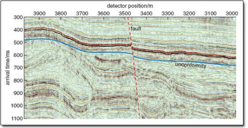
The hydrophones therefore detect ;bundles; of seismic waves arriving at different times because they have travelled by different routes through the rock sequence. Computer processing allows the amalgamation of recordings from all the shot points, filtering out unwanted signals of various sorts. The final result is a two-dimensional (2-D) seismic section.
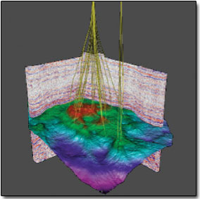
By using closely spaced survey lines or hydrophones arranged in a grid it is possible to produce 3-D seismic datasets. These are usually interpreted on a PC workstation and colours are normally used to enhance the image and aid interpretation. The data can be viewed in any orientation in order to create a 3-D visualisation of selected horizons
Exploration drilling
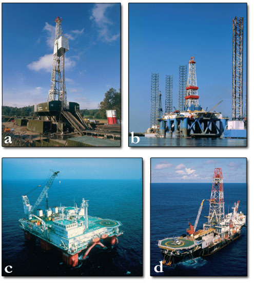
(a) - jack up rig for land (b) jack up rig for sea up to 200m deep (c) semi-submercible ocean rig for deep water (d) ship mounted rig for very deep water
When seismic data highlight a suitable prospect, the next step is to drill into the reservoir in order to establish whether or not petroleum is trapped, and, if it is, to establish how large the accumulation might be.
Components of a land rig could be taken into the rainforest by river boats or helicopters and assembled on site. Before that process began it would be essential to survey the drilling site, determine the best access route, clear the site sensitively and safeguard local water supplies from any risk of contamination. In ecologically sensitive areas the cost of site preparation and restoration may exceed the drilling costs.
Drilling for oil and gas is a sophisticated and very expensive process. Wells often penetrate over 3000 m into sedimentary rock; the deepest exceed 6500 m. At such depths the fluid pressures in the rock formations are so high that a dense drilling mud is continuously pumped into the borehole to counter-balance the pressure.
Well evaluation
To some extent, well evaluation is similar to evaluation of coalfields. Traditionally an exploration well is evaluated at discrete stages by withdrawing the drill bit, lowering instruments (colloquially known as ‘tools’) down the hole on a steel cable and then hauling them slowly back to surface. This process is known in the petroleum industry as wireline logging. As the tools are withdrawn they record the properties of the rocks that surround the well and the fluids in them. Nowadays this approach is supplemented by measurements that are made while drilling is in progress, which has the advantages of providing near instantaneous data and incurs none of the expense of halting the drilling process.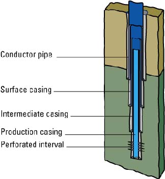
The rock properties that are of interest include those used for identifying lithologies and small-scale structural or sedimentological features. Other tools help estimate porosity, permeability, pressure and fluid content. None provide a completely definitive description of the borehole wall, but in combination the data acquired by wireline logging provide sufficient information to determine whether further evaluation is justified.
The most useful geological data are derived from pieces of rock recovered from specific depth intervals. They range in size from small fragments of rock (drill cuttings) produced as the drill bit cuts into rock, to thumb-size and larger (5–15 cm diameter) cores of solid rock that are retrieved with special tools. These provide the basis for a detailed description of the reservoir, although cores may also be taken in mudstones to gain biostratigraphic and/or geochemical information.
Some exploration wells, particularly those that encounter significant volumes of petroleum, justify an extensive evaluation programme that is designed to recover fluid samples from selected intervals down the well. The fluids (oil, gas and water) are captured in situ at reservoir temperature and pressure, and then brought to the surface in a small sealed chamber for analysis. Less commonly, the fluids may be sampled by allowing them to flow to the surface. Such well testing may continue for several days. During that time it is possible to draw some preliminary conclusions about the nature of the reservoir, flow rates and the commercial potential of the petroleum accumulation
Oil sands
Non-conventional sources of petroleum, such as oil sands, heavy oil and gas hydrates, greatly exceed the world's entire endowment of conventional petroleum. Yet, because of technological, commercial and environmental constraints to production, non-conventional petroleum currently accounts for only about 5% of global consumption. This huge imbalance will slowly change as the inevitability of declining conventional petroleum reserves and increasing prices hits home.
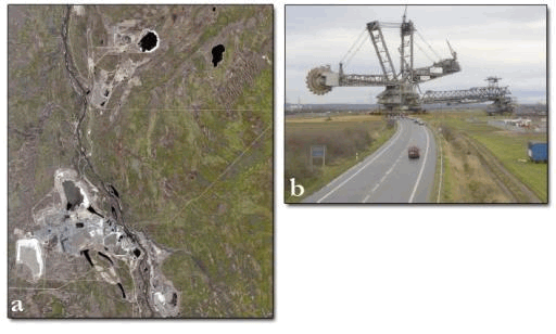
If a near-surface rock has good reservoir properties, large volumes of oil can flow into it from mature source rocks buried deep below. Exposure of crude oil to air and bacteria close to the surface degrades it to thick, viscous bitumen. Over time, tens of metres of rock from the surface downward can become completely impregnated with bitumen, forming a deposit known as oil sand. Oil sand is composed of bitumen, sand, clays and water.
Bitumen, in its raw state, is black and thicker than treacle. It requires treatment to make it fluid enough to transport by pipeline and to be usable by conventional refineries. The process involves large-scale surface strip-mining of enormous volumes of oil sand.
The sands are then heated to between 35–80 °C to separate and chemically change the bitumen to lighter hydrocarbons using water-based extraction methods. The upgraded product consists of light and heavy oils that are blended to produce a light crude oil with a low sulphur and nitrogen content.
Gas hydrates
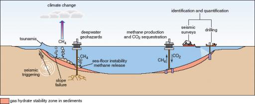
The temperature and pressure of the deep oceans are controlled, respectively, by deep, cold currents that move from polar latitudes along the sea floor and by the mass of the overlying water column. Consequently, at depths exceeding 300–500 m the sea floor is at a temperature of around 1–2 °C and a pressure that is several hundred times greater than atmospheric pressure. Under these physical conditions, gases such as methane (CH4) and carbon dioxide (CO2) can combine with water to form solid, ice-like crystalline compounds known as gas hydrates (see Section 5.2.2, Figure 14). Clearly, economically interesting gas hydrates are those which contain proportionally far more hydrocarbon gases in their structure than CO2. Depending on the geothermal gradient, the base of the hydrate stability zone may extend to depths of more than 1000 m beneath the ocean floor.
Hydrocarbon gas hydrates can form in deep ocean water but they are not found as a carpet on the sea floor. This is because such hydrates have a lower density than that of seawater (850 kg m−3 compared with 1025 kg m−3). As soon as they form, they float upwards and turn back into methane and water in the lower pressures and warmer temperatures of the upper layers of the ocean. However, within the sediments just beneath the sea floor, crystals of hydrocarbon gas hydrate form and move upwards buoyantly. Frequently the rising crystals form a ‘log-jam’ within the pore space of the sediment and once this occurs, more gas hydrate crystals become trapped in the pore spaces beneath. Eventually, all available pore spaces in the sediment become completely filled by gas hydrate crystals that readily absorb methane into their lattice. Fully saturated gas hydrates can hold up to 200 times their own volume of methane, creating a zone that is denser than seawater and thus gravitationally stable.
Oil Shale Fracking
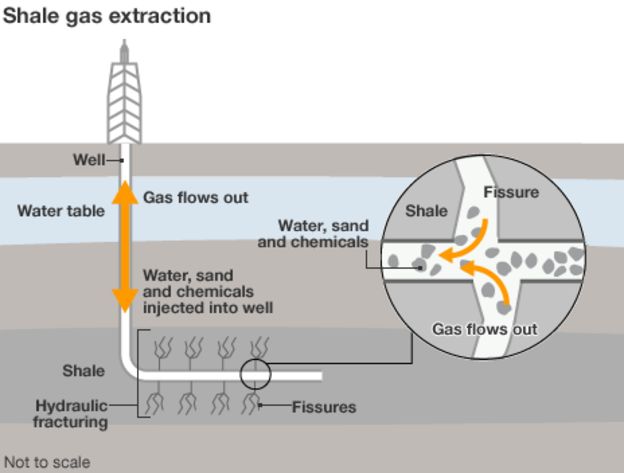
Hydraulic fracturing, or fracking, is a technique designed to recover gas and oil from shale rock. But how does it work and why is it controversial? Fracking is the process of drilling down into the earth before a high-pressure water mixture is directed at the rock to release the gas inside. Water, sand and chemicals are injected into the rock at high pressure which allows the gas to flow out to the head of the well.The process can be carried out vertically or, more commonly, by drilling horizontally to the rock layer and can create new pathways to release gas or can be used to extend existing channels.The term fracking refers to how the rock is fractured apart by the high pressure mixture
Fracking allows drilling firms to access difficult-to-reach resources of oil and gas.
The extensive use of fracking while it has revolutionised the energy industry, has prompted environmental concerns.Fracking uses huge amounts of water, which must be transported to the fracking site, at significant environmental cost.Environmentalists say potentially carcinogenic chemicals used may escape and contaminate groundwater around the fracking site. The industry suggests pollution incidents are the results of bad practice, rather than an inherently risky technique. There are also worries that the fracking process can cause small earth tremors.Campaigners say that fracking is simply distracting energy firms and governments from investing in renewable sources of energy, and encouraging continued reliance on fossil fuels.