Subsidence / Collapse / Cave Formation
Subsidence / Collapse / Cave Formation
based on the lecture notes of Prof. Stephen A. Nelson, Tulane University
Karst
Caves
Sinkholes
Removal of Salt
Coal
Fluid Withdrawal
Groundwater
Oil and Gas
Sinking Cities
Surface Subsidence and Collapse
Subsidence hazards involve either the sudden collapse of the ground to form a depression or the slow subsidence or compaction of the sediments near the Earth's surface. Sudden collapse events are rarely major disasters, certainly not anywhere near the scale of the earthquake, volcanic, tsunami, or landslide disasters, but the slow subsidence of areas can cause as much economic damage, although spread out over a longer period of time.
Carbonate Dissolution and
Karst Topography
Carbonate rocks such as limestone, composed mostly of the mineral calcite (CaCO3) are very susceptible to dissolution by groundwater during the process of chemical weathering. Such dissolution can result in systems of caves, sinkholes, and eventually to karst topography.
Dissolution
Water in the atmosphere can dissolve small amounts of carbon dioxide (CO2 ). This results in rain water having a small amount of carbonic acid (H2CO3) when it falls on the Earth's surface. As the water infiltrates into the groundwater system and encounters carbonate rocks like limestone, it may start to dissolve the calcite in the limestone by the following chemical reaction:
CaCO3 + H2CO3 = Ca+2 + 2HCO3-2,
which states that calcite reacts with carbonic acid to produce dissolved Calcium ion plus dissolved Bicarbonate ion.
This reaction takes place as the water moves along fractures and other partings or openings in the rock. This results in dissolution of much of the limestone if the reaction continues to take place over a long period of time.
Caves & Cave Formation
Caves are large underground open spaces. If there are many interconnected chambers in a cave system, it is called a cavern. Most caves are formed by the chemical dissolution process described above, as a result of circulating groundwater. The dissolution begins along fracture systems in the rock, widening the fractures and connecting them to other fractures, until a cave is formed.
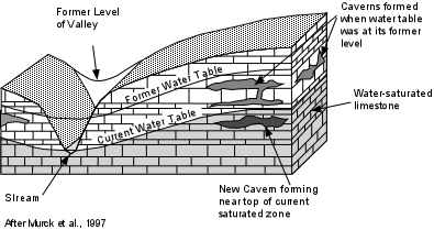
Most caves are thought to form near the water table (the surface below which all open space in rock is filled with water) , and thus the openings are initially filled with water.
After the water table is lowered due to changing geologic conditions, further seepage of water into the now open cave system results in the deposition of stalactites (icicle like stones) where the water drips into the cave. If water is absent from the floor of the cave stalagmites form where the water drips on the floor of the cave. Both stalactites and stalagmites are composed of newly precipitated calcite, initially dissolved from the limestone above, carried in the groundwater, and re-precipitated when the water reaches a low pressure area like a cave.
The rate at which caves form depends on such factors as the acidity of the water and the velocity at which the water moves through the rock. Highly acidic water and high flow velocity increase the rate of dissolution, and thus the rate at which a cave forms. Based on observations of the rate of dissolution from currently forming caves, it appears that the cave formation process can take anywhere between 10,000 years and 1 million years.
Sinkholes
A sinkhole is a large dissolution cavity that is open to the Earth's surface. Some sinkholes form when the roofs of caves collapse, others can form at the surface by dissolving the rock downward. Because we are here concerned with subsidence disasters and hazards we will concentrate on the formation of sinkholes by collapse.
Sinkholes are common in areas underlain by limestone. Central Florida is such an area, and in one small area of about 25 km2, over 1000 sinkholes have formed by collapse in recent years.
Sinkholes may form as a result of lowering the water table by excessive pumping for human use of the water. This appears to be responsible for sinkhole formation in Florida.
Caverns that were forming just below the water table were filled with water. The water table was lowered over the years resulting in the level of groundwater in the caverns to become lower. While the water table was high, the water in the cavern helped to support the roof of the cavern. This support is removed when the water table is lowered, and thus the unsupported roof eventually becomes unstable and collapses to form a sinkhole.
Sinkholes may also form by slow enlargement of caverns by continued dissolution of the limestone. This may no matter what the level of the water table.
When sinkholes collapse to expose the water table at the surface, the sinkhole will be filled with water forming small circular lakes.
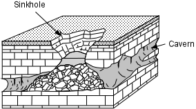
Although common in areas underlain by limestone, sinkholes can form in any area where highly water soluble rocks occur close to the surface. Such rocks include rock salt made of the mineral halite, and gypsum deposits, both of which easily dissolve in groundwater.
Karst Topography
In areas where highly water soluble materials lie close the surface, dissolution below the surface can eventually lead to the formation of caverns and sinkholes. As the sinkholes begin to coalesce, the surface topography will become chaotic, with many enclosed basins, and streams that disappear into sinkholes, run underground and reappear at springs. Such a chaotic topography is known as karst topography. Karst topography starts out as an area with many sinkholes, but eventually, as weathering and dissolution of the underlying rock continue, the ground surface may be lowered, and areas that have not undergone extensive dissolution stand up as towering pillars above the surrounded terrain. The latter type of karst is called tower karst.
Removal of Solids and Mine Related Collapse
Humans can play a large role causing collapse of the surface. Mining activities that remove material from below the surface can result in collapse if precautions are not taken to ensure that the there is adequate support for the overlying rocks.
Removal of Salt
Salt occurs beneath the surface in areas that were once below sea level in restricted basins where extensive evaporation caused the concentration of salt in seawater to become so high that the salt was precipitated on the bottom. This occurred, for example during the Jurassic Period (about 150 million years ago) in the area of the Gulf of Mexico. Later deposition of other sediments on top of this salt, resulted in low density salt underlying higher density sediments. Since salt is rather ductile, it began to flow upward toward the surface, and in many cases became detached from the original layer of salt at depth to form what is called a salt dome. Since the salt now occurs close to the surface, it can dissolve and collapse to form sinkholes.
The salt can also be mined to produce salt for human usage. One mining technique involves injecting fluids into the salt to dissolve it. The fluids are then recovered and the salt re-precipitated from the solutions. Such mining, because it dissolves large cavities in the salt can lead to instability and collapse. Such solution mining resulted in a sinkhole 300 m in diameter in Hutchinson Kansas .
Another salt mine related collapse occurred as the result of oil exploration near a salt dome at Jefferson Island in southwestern Louisiana. Jefferson Island is not an island in the strict sense, but is an area of high topography that formed as the result of salt moving upward through the sediments and uplifting the surface. The salt dome contained active salt mines, where mining was accomplished by digging tunnels in the salt. An oil company attempted to drill a well from a lake adjacent to Jefferson Island, hoping to skirt the edge of the salt dome and find oil. Instead, the oil well penetrated the salt and entered one of the mining tunnels. This cause the lake to drain into the salt mine, which then caused some of the salt to dissolve. Eventually this undermined support above the mines and led to collapse of the surface. The lake drained into the salt mine, ten barges used for oil drilling were sucked into the hole, and a home and entire botanical garden collapsed into the depression. Fortunately no miners or other inhabitants of the area were killed .
Coal Mining
Since mining often removes material from below the surface without dissolution, mining can create voids that may become unstable and collapse.
Coal occurs beneath the surface as extensive layers called coal seams.
These seams were once swampy areas on the surface where much vegetation flourished, died, and became buried before it could decay. Processes acting over long periods of geologic time have turned dead vegetation into coal. Other useful substances are mined by digging tunnels in rock, but in most mining techniques the useful substance occurs along narrow zones only these enriched zones need to be removed. In mining coal, however, all of the material is useful, so large masses of material are removed. The technique used in coal mining is referred to as "room-and-pillar" mining. The rooms are where the coal has been removed, and the pillars are left to support the overlying rock. Sometimes, too few pillars are left, and the overlying rock collapses into the mine. This is not only dangerous to the miners, but can also cause hazards to areas on the surface where the collapse occurs
Underground fires in coal mines can also lead to collapse hazards.
Fires can start by spontaneous ignition of coal dust or methane gas released from the coal. Such fires are difficult to extinguish, and often are left to burn for years. In Pennsylvania, for example, coal mine fires have burned for more than 25 years. Burning of the coal results in removal of the coal, and thus may undermine support for the roof of the mine resulting in collapse.
Subsidence Caused by:
Fluid Withdrawal
We have seen how fluids (particularly water) in the subsurface can dissolve rock to undermine support and cause collapse of the surface. Here we look at another role that fluids may play in causing subsidence. Any fluid that exists in the pore spaces or fractures of rock is under pressure due to the weight of the overlying rock. So long as the pressure of the fluid is enough to support the overlying rock, no subsidence at the surface will occur. But, if fluids are withdrawn from below the surface, a decrease in fluid pressure may occur resulting in the removal of support and possible collapse. The two most important fluids that occur beneath the surface are water (in the form of groundwater) and petroleum (in the form of oil and natural gas). Both of these fluids are often withdrawn for human use, and thus humans are often responsible for fluid withdrawal related subsidence. But, such withdrawal can also occur by natural processes.
Groundwater
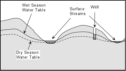
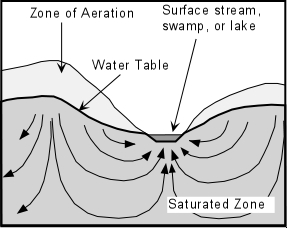
Groundwater occurs nearly everywhere below the surface of the Earth, where, as we have said before, it fills the pore spaces and fractures in rock at levels below the water table. The zone beneath the water table is called the saturated zone. Groundwater flows into the saturated by percolation downward from rainfall on the surface. Surface bodies of water, like streams, lakes, and swamps, are areas where the water table is exposed at the surface. Springs are also areas where the water table is exposed at the surface. If one digs or drills a well to intersect the water table, water will flow into the well and fill it to the level of the water table. The level of the water table can change as a result of changing amounts of input in the groundwater system (called recharge) and output from the groundwater system (called discharge). Recharge takes place by water infiltrating down from the surface. Discharge occurs as a result of outflow through surface bodies of water, springs, and wells. During the wet season the water table is generally higher because recharge exceeds discharge. During dry seasons the water table is depressed because discharge exceeds recharge. Likewise, during periods of drought the water will be lower.
Groundwater moves through the saturated zone both downward and upward. The downward flow occurs due to gravity and the upward flow occurs because fluids tend to flow towards areas of lower pressure.
Subsidence can be caused by any process that results in lowering of the water table. So, drought, dry seasons, and excessive withdrawal of groundwater by humans can cause the water table to move to deeper levels and result in subsidence.
Most subsidence occurs as a result of hydrocompaction, discussed previously under mass wasting processes. Hydrocompaction occurs when the sediments loose water. Since lowering of the water table involves loss of water, hydrocompaction often occurs.
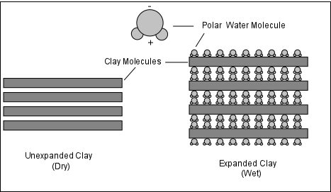
Hydrocompaction means that water absorbed on and within clay minerals are removed by withdrawal or drying and the clays shrink. Shrinkage of clays results in less volume, so the surface will subside as the clays become more tightly compacted.
Hydrocompaction also occurs when organic rich sediment like peat is subjected to loss of water. For example, in southern Florida, swamp with organic rich soils containing both peat and clay minerals was drained for agricultural use. In 1912 drainage canals were installed throughout the swamp to drain water. This resulted in lowering the water table and hydrocompaction of the soil led to some subsidence. In 1942 further drainage of the area was undertaken by installing pumps to pump out the groundwater. Subsidence due to hydrocompaction increased again. By 1980 the land surface had subsided about 2.8 m from its original elevation.
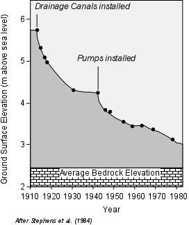

After Coch (1995)
Most hydrocompaction is an elastic deformation process. Recall that elastic deformation is reversible, so that when the clays or peat dry out they compact, but when they become wet once again, they expand. Compaction, however, can become inelastic, which is not reversible. In such a case as the pores are closed by compaction, they cannot be restored when new fluids are pumped in.
The rate of subsidence relative to rate of fluid withdrawal can sometimes show when material passes from elastic compaction to inelastic compaction. If the rate of fluid withdrawal is large yet the rate of subsidence is small, this is usually an indication of elastic compaction. If, however, there is a large amount of subsidence with only small amounts of fluid withdrawal, inelastic compaction is likely occurring.
For example, in the Tucson Basin of southern Arizona, prior to 1981 the ground surface dropped about 3 mm for every meter of lowering of the water table. Since 1981, for every meter lowering of the water table a 24 mm lowering of the land surface has been observed. This 8-fold increase in the rate of subsidence relative to the level of the water table likely indicates that inelastic compaction is occurring. If so, then the subsidence cannot be reversed by raising the water table.
Oil & Gas
Oil and Natural gas are both fluids that can exist in the pore spaces and fractures of rock, just like water. When oil and natural gas are withdrawn from regions in the Earth near the surface, fluid pressure provided by these fluids is reduced. With a reduction in fluid pressure, the pore spaces begin to close and the sediment may start to compact resulting in subsidence of the surface.
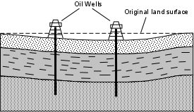
This has occurred recently in the oil fields of southern California. For example, in the Wilmington oil field of Long Beach, California, subsidence was first recognized in 1940 due to withdrawal of oil from the subsurface. The area affected was about 50 km2. Near the center of this area, the surface subsided by up to 9 meters . In 1958 repressurization of the area was attempted by pumping fluids back into the rocks below. By 1962 further subsidence had been greatly reduced, and the area continuing to subside had been reduced to 8 km2. Still, up to this point, very little uplift had occurred to restore the area to its original elevation. This subsidence event has cost over $100 million.
Sinking Cities
Cities built on unconsolidated sediments consisting of clays, silt, peat, and sand are particularly susceptible to subsidence. Such areas are common in delta areas, where rivers empty into the oceans, along floodplains adjacent to rivers, and in coastal marsh lands. In such settings, subsidence is a natural process Sediments deposited by the rivers and oceans get buried, and the weight of the overlying, newly deposited sediment, compacts the sediment and the material subsides. Building cities in such areas aggravates the problem for several reasons.
Construction of buildings and streets adds weight to the region and further compacts the sediment.
Often the areas have to be drained in order to be occupied. This results in lowering of the water table and leads to hydrocompaction.
Often the groundwater is used as a source of water for both human consumption and industrial use. This also results in lowering the water table and further hydrocompaction.
Levees and dams are often built to prevent or control flooding. This shuts off the natural supply of new sediment to the area. In a natural setting sedimentation resulting from floods helps replenish the sediment that subsides and thus builds new material over the subsiding sediment, decreasing the overall rate of subsidence. When the sediment supply is cut off, the replenishment does not occur and the rate of subsidence in enhanced.
Many subsiding cities are coastal cities like London, Houston, and Venice, or are built on river flood plains and deltas, like New Orleans, Baton Rouge, and the San Joaquin Valley of central California. Mexico City is somewhat different in that it was built in a former lake.
Predicting and Mitigating Subsidence Hazards
The exact place and time of a disaster related to subsidence cannot usually be predicted with any degree of certainty. This is true of both slow subsidence related to fluid withdrawal and sudden subsidence related to sinkhole formation or mine collapse.
Mitigation is the best approach to these hazards. In an ideal world, all areas susceptible to such hazards would be well known and actions would be taken to either avoid causing the problem if it is human related, or avoid inhabitance of such areas if they are prone to natural subsidence.
For subsidence caused by sudden collapse of the ground to form sinkholes, several measures can be taken. First, geologists can make maps of areas known to be underlain by rocks like limestone, gypsum, or salt, that are susceptible to dissolution by fluids. Based on knowledge of the areas, whether active dissolution is occurring or has occurred in the recent past, and knowing something about the depth below the surface where these features occur, hazard maps can be constructed.
Once these areas have been identified, detailed studies using drill holes, or ground penetrating radar can be used to locate open cavities beneath the surface. These areas can then be avoided when it comes time for decisions about land use.
In areas where there is a possibility of sudden collapse, one should be aware of any cracks that form in the ground. especially if the cracks start to form a circular or elliptical pattern. Such ground cracking may be an indication that a collapse event is imminent.
In areas located above known mining operations or former mining operations, maps can be constructed based on knowledge of the actual locations of open cavities beneath the surface. Such maps can then be used as a guide for land use planning. Currently laws are in place to prevent active mining beneath urban areas, but these laws did not always exist, and older mines could still cause problems.
Where fluid withdrawal is the main cause of subsidence, information on the rate of fluid withdrawal should be determined and combined with studies of the material in the subsurface based on sampling with drill core methods. If subsidence is suspected or observed, human activities can be modified to prevent further subsidence. For example new sources of water can often be found, or waste water can be treated and pumped back into the ground to help maintain the level of the water table, maintain fluid pressure, or re-hydrate hydrocompacting clays and peat.
Fluid withdrawal problems are complicated in the United States where laws are in conflict. Rights to withdrawal of an underground resource like water or oil usually take precedence over the rights to sue for damages that might result from subsidence.

