Earthquake Prediction and Control
Earthquake Prediction and Control
based on the lecture notes of Prof. Stephen A. Nelson - Tulane University
Long-Term Forecasting
Long-term forecasting is based mainly on the knowledge of when and where earthquakes have occurred in the past. Thus, knowledge of present tectonic setting, historical records, and geological records are studied to determine locations and recurrence intervals of earthquakes. Two aspects of this are important.
Paleoseismology
- the study of prehistoric earthquakes. Through study of the offsets in sedimentary layers near fault zones, it is often possible to determine recurrence intervals of major earthquakes prior to the recorded historical record. If it is determined that earthquakes have recurrence intervals of say 1 every 100 years, and there are no records of earthquakes in the last 100 years, then a long-term forecast can be made and efforts can be undertaken to reduce seismic risk.
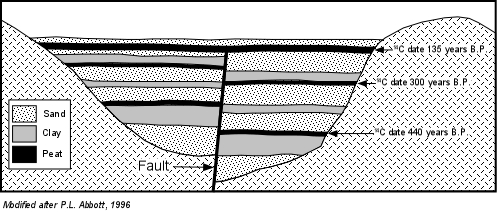
Example: The diagram below shows a hypothetical cross-section of a valley along a fault zone. The valley has been filled over the years with clays, sands, and peat (decaying organic matter). The upper peat layer is not yet cut by the fault. Peat is a useful material to geologists, since it contains high amounts of Carbon that can be dated using the 14C method. The ages for each of the peat layers are shown. The dates suggest that a major faulting event cut the lower peat layer sometime after it was deposited 440 years ago. The dates also show the middle peat layer was cut by a faulting event after it was deposited 300 years ago. If these faulting events were associated with earthquakes, this suggests a recurrence interval of about 140 years. Since the upper peat layer has not yet been cut by the fault and is 135 years old, we can speculate that within the next 10 years or so there may be another earthquake. This assumes, of course, that the two previous events are an accurate measure of the recurrence interval.

Seismic gaps - A seismic gap is a zone along a tectonically active area where no earthquakes have occurred recently, but it is known that elastic strain is building in the rocks. If a seismic gap can be identified, then it might be an area expected to have a large earthquake in the near future.
Example - The Mexico Earthquake of 1985
The map below shows the southern coast of Mexico. Here the Cocos plate is subducting beneath the North American Plate along the Acapulco Trench. Prior to the September of 1985 it was recognized that within recent time there had been major and minor earthquakes on the subduction zone in a cluster pattern. For example, there were clusters of earthquakes around a zone that included a major earthquake on Jan 30, 1973, another cluster around an earthquake of March 14, 1979, and two more cluster around earthquakes of July 1957 and January, 1962. Between these clusters were large areas that had produced no recent earthquake activity. The zones with low seismically are called seismic gaps. Because the faulting had occurred at other places along the subduction zone it could be assumed that strain was building in the seismic gaps, and earthquake would be likely in such a gap within the near future. Following a magnitude 8.1 earthquake on September 19, 1985, a magnitude 7.5 aftershock on Sept. 21, and a magnitude 7.3 aftershock on Oct. 25, along with thousands of other smaller aftershocks, the Michoacan Seismic gap was mostly filled in. Note that there still exists a gap shown as the Guerrero Gap and another farther to the southeast. Over the next 5 to ten years we may expect to see earthquakes in these gaps.

Example - The San Francisco, Loma Prieta, and Parkfield Seismic Gaps
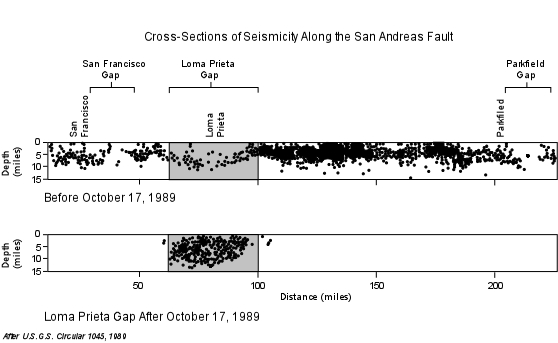
Shown below are two cross-sections along the San Andreas Fault in northern California. The upper cross section shows earthquakes that occurred along the fault prior to October 17, 1989. Three seismic gaps are seen, where the density of earthquakes appears to be lower than along sections of the fault outside the gaps. To the southeast of San Francisco is the San Francisco Gap, followed by the Loma Prieta Gap, and the Parkfield Gap. Because of the low density of density of earthquakes in these gaps, the fault is often said to be locked along these areas, and thus strain must be building. This led scientist to issue a prediction for the Parkfield gap that sometime between 1986 and 1993 there would be an earthquake of magnitude 6 or greater south of Parkfield. No such earthquake has yet occurred. However a magnitude 7.1 earthquake occurred in the Loma Prieta gap on Oct. 17, 1989, followed by numerous aftershocks. Note how in the lower cross-section, this earthquake and its aftershocks have filled in the Loma Prieta Gap. This still leaves the San Francisco and Parkfield gaps as areas where we might predict a future large event.

Short-Term Prediction
- Short-term predication involves monitoring of processes that occur
in the vicinity of earthquake prone faults for activity that signify a
coming earthquake.
- Anomalous events or processes that may precede an earthquake are
called precursor events and might signal a coming earthquake.
- Despite the array of possible precursor events that are possible to
monitor, successful short-term earthquake prediction has so far been
difficult to obtain. This is likely because:
- the processes that cause earthquakes occur deep beneath the
surface and are difficult to monitor.
- earthquakes in different regions or along different faults all
behave differently, thus no consistent patterns have so far been
recognized.
- the processes that cause earthquakes occur deep beneath the
surface and are difficult to monitor.
- Ground Uplift and Tilting of the ground - Measurements taken in the
vicinity of active faults sometimes show that prior to an earthquake
the ground is uplifted or tilts due to the swelling of rocks caused by
strain building on the fault. This may lead to the formation of
numerous small cracks (called microcracks). This cracking in
the rocks may lead to small earthquakes called foreshocks.
- Foreshocks - Prior to a 1975 earthquake in China, the observation
of numerous foreshocks led to successful prediction of an earthquake
and evacuation of the city of the Haicheng. The magnitude 7.3
earthquake that occurred, destroyed half of the city of about 100
million inhabitants, but resulted in only a few hundred deaths because
of the successful evacuation..
- Water Level in Wells - As rocks become strained in the vicinity of a fault, changes in pressure of the groundwater (water existing in the pore spaces and fractures in rocks) occur. This may force the groundwater to move to higher or lower elevations, causing changes in the water levels in wells.
- Emission of Radon Gas - Radon is an inert gas that is produced by the radioactive decay of uranium and other elements in rocks. Because Radon is inert, it does not combine with other elements to form compounds, and thus remains in a crystal structure until some event forces it out. Deformation resulting from strain may force the Radon out and lead to emissions of Radon that show up in well water. The newly formed microcracks discussed above could serve as pathways for the Radon to escape into groundwater. It has been reported that increases in the amount of radon emissions increases prior to some earthquakes.
- Changes in the Electrical Resistivity of Rocks - Electrical resistivity is the resistance to the flow of electric current . In general rocks are poor conductors of electricity, but water is more efficient a conducting electricity. If microcracks develop and groundwater is forced into the cracks, this may cause the electrical resistivity to decrease (causing the electrical conductivity to increase). In some cases a 5-10% drop in electrical resistivity has been observed prior to an earthquake.
- Unusual Radio Waves - Just prior to the Loma Prieta Earthquake of 1989, some researchers reported observing unusual radio waves. Where these were generated and why, is not yet known, but research is continuing.
- Strange Animal Behavior - Prior to a magnitude 7.4 earthquake in Tanjin, China, zookeepers reported unusual animal behavior. Snakes refusing to go into their holes, swans refusing to go near water, pandas screaming, etc. This was the first systematic study of this phenomenon prior to an earthquake. Although other attempts have been made to repeat a prediction based on animal behavior, there have been no other successful predictions.
Examples of human induced earthquakes
- For ten years after construction of the Hoover Dam in Nevada blocking the Colorado River to produce Lake Mead, over 600 earthquakes occurred, one with magnitude of 5 and 2 with magnitudes of 4.
- In the late 1960s toxic waste injected into hazardous waste disposal wells at Rocky Flats, near Denver apparently caused earthquakes to occur in a previously earthquake quiet area. The focal depths of the quakes ranged between 4 and 8 km, just below the 3.8 km-deep wells.
- Nuclear testing in Nevada set off thousands of aftershocks after the explosion of a 6.3 magnitude equivalent underground nuclear test. The largest aftershocks were about magnitude 5.
The problem, however, is that of the energy involved. Remember that for every increase in earthquake magnitude there is about a 30 fold increase in the amount of energy released. Thus, in order to release the same amount of energy as a magnitude 8 earthquake, 30 magnitude 7 earthquakes would be required. Since magnitude 7 earthquakes are still very destructive, we might consider generating smaller earthquakes. If we say that a magnitude 4 earthquake might be acceptable, how many magnitude 4 earthquakes are required to release the same amount of energy as a magnitude 8 earthquake? Answer 30 x 30 x 30 x 30 x 30 = 810,000! Still, in the future it may be possible to control earthquakes either with explosions to gradually reduce the stress or by pumping fluids into the ground.

