Earthquake Hazards and Risks
Earthquake Hazards and Risks
adapted from lecture notes of Prof. Stephen A. Nelson Tulane University
- Many seismologists have said that "earthquakes don't kill people, buildings do". This is because most deaths from earthquakes are caused by buildings or other human construction falling down during an earthquake.
- Earthquakes located in isolated areas far from human population rarely cause any deaths.
- Thus, earthquake hazard risk depends on
- Population density
- Construction standards (building codes)
- Emergency preparedness
Worst earthquake in recorded history: . January 23, 1556 - The earthquake occurred near Huaxian, Shaanxi (formerly Shensi), China, about 50 miles (80 km) east-northeast of Xi'an, the capital of Shaanxi. More than 830,000 people were killed. Damage extended as far away as Taiyuan, the capital of Shanxi (formerly Shansi) and about 270 miles (430 km) northeast of the epicenter. There are felt reports as far away as Liuyang in Hunan, more than 500 miles (800 km) away. Geological effects reported with this earthquake included ground fissures, uplift, subsidence, sandblows, liquefaction and landslides. Most towns in the damage area reported city walls collapsed, most to all houses collapsed and many of the towns reported ground fissures with water gushing out (ie. liquefaction and sandblows). Gu, et.al. says that "the identified death toll of soldiers and civilians was 830,000, and the unidentified was uncountable." The earthquake was felt in all or parts of 9 provinces: Anhui, Gansu, Hebei, Hubei, Henan, Hunan, Shaanxi, Shandong and Shanxi. The maximum intensity is XI in the Huaxian-Weinan area and the estimated magnitude is 8.
In Huaxian, "city walls, temples, offices and civilian houses were demolished, without a single wall left standing.... The ground fissured and sunk. Water gushed out and formed canals. Sixty percent of the people (several tens of thousands were killed or injured."
In Weinan [15 miles (24 km) west of Huaxian], "city walls, temples, storehouses, offices and civilian houses collapsed totally.... In the city, the ground sunk for more than 3 meters. Fifty percent of the people were killed."
In Xi'an [one of China's major cities then as it is now], "city walls, storeyed buildings and terraces collapsed. Most temples were destroyed. More than half of the houses toppled down. Only 10-20 percent of the walls were left standing. The ground fissured crisscross. Thirty percent of the people were killed."
Even as far away as Taiyuan, "houses were destroyed in great numbers."
In many references, this earthquake is referred to as the "Shensi Province earthquake of 1556" using the old spelling for the province.
Source US Geological Surveyhttp://earthquake.usgs.gov/
Worst earthquake in this century also occurred in China Tangshan, Tianjin Provence, killed 240,000 in 1976. Occurred at 3:42 AM, Magnitude 7.8 Earthquake and magnitude 7.1 aftershock. Deaths were due to collapse of masonry (brick) buildings.
Contrast - In earthquake prone areas like California, in order to reduce earthquake risk, there are strict building codes requiring the design and construction of buildings and other structures that will withstand a large earthquake. While this program is not always completely successful, one fact stands out to prove its effectiveness.
In 1989 an earthquake near San Francisco, California (The Loma Prieta, or World Series Earthquake) with a Richter Magnitude of 7.1 killed about 62 people. Most were killed when a double decked freeway in Oakland collapsed. About 10 months later, an earthquake with magnitude 6.9 occurred in Armenia, where no earthquake proof building codes existed. The death toll in the latter earthquake was about 25,000!
Computer simulations for large cities, like San Francisco or Los Angeles, California, indicate that a magnitude >8.0 earthquake would cause between 3,000 and 13,000 deaths.
- 3,000 if at night, when populace is asleep in wood frame houses
- 13,000 if during day when populace is in masonry buildings and on
freeways.
While architecture and building codes can reduce risk, it should be noted that not all kinds of behavior can be predicted.
Although codes are refined each year, not all possible effects can be anticipated. For example different earthquakes show different frequencies of groundshaking, different durations of groundshaking, and different vertical and horizontal ground accelerations.
Old buildings cannot cost-effectively be brought up to code, especially with yearly refinements to code.
Even with construction to earthquake code, buildings fail for other reasons, like poor quality materials, poor workmanship, etc. that are not discovered until after an earthquake.
Seismic Hazard and Risk Mapping
The risk that an earthquake will occur close to where you live depends on whether or not tectonic activity that causes deformation is occurring within the crust of that area. (See figure 3.18 in your text).
For the U.S., the risk is greatest in the most tectonically active area, that is near the plate margin in the Western U.S. Here, the San Andreas Fault which forms the margin between the Pacific Plate and the North American Plate, is responsible for about 1 magnitude 8 or greater earthquake per century.
Also in the western U.S. is the Basin and Range Province, where extensional stresses in the crust have created many normal faults that are still active.
Historically, large earthquakes have also occurred in the area of New Madrid, Missouri; Charleston, South Carolina; Boston, Massachusetts; and along the St. Lawrence River near the New York - Canada Border. Why earthquakes occur in these other areas is not well understood, However, if earthquakes have occurred before, they are expected to occur again.
Another way of looking a seismic risk that is more useful to construction designers and engineers, and therefore to the development of building codes is based on expected horizontal ground acceleration. Acceleration is measured relative to the acceleration due to gravity (g, 980 cm/sec2). Ground accelerations of 0.1g are considered able to cause damage. Figure 3.19 in your text shows a seismic risk map based on ground acceleration, with the probability that such accelerations will occur in any 50 year period being 1 in 10.
Hazards Associated with Earthquakes
Possible hazards from earthquakes can be classified as follows:
Ground Motion - Shaking of the ground caused by the passage of seismic waves, especially surface waves near the epicenter of the earthquake are responsible for the most damage during and earthquake. The intensity of ground shaking depends on:
- Local geologic conditions in the area. In general, loose unconsolidated sediment is subject to more intense shaking than solid bedrock.
- Size of the Earthquake. In general, the larger the earthquake, the more intense is the shaking and the duration of the shaking.
- Distance from the Epicenter. Shaking is most severe near the epicenter and drops off away from the epicenter. The distance factor depends on the type of material underlying the area. There are, however, strange exceptions. For example, the 1985 Mexico City Earthquake (magnitude 8.1) had an epicenter on the coast of Mexico, more than 350 km to the south, yet damage in Mexico City was substantial because Mexico City is built on soft unconsolidated sediments that fill a former lake (see Liquefaction, below).
- Damage to structures from shaking depends on the type of
construction.
- Concrete and masonry structures are brittle and thus more susceptible to damage
- wood and steel structures are more flexible and thus less susceptible to damage.
Aftershocks - These are usually smaller earthquakes that occur after a main earthquake, and in most cases there are many of these (1260 were measured after the 1964 Alaskan Earthquake). Aftershocks occur because the main earthquake changes the stress pattern in areas around the epicenter, and the crust must adjust to these changes. Aftershocks are very dangerous because they cause further collapse of structures damaged by the main shock.
Fire - Fire is a secondary effect of earthquakes. Because power lines may be knocked down and because natural gas lines may rupture due to an earthquake, fires are often started closely following an earthquake. The problem is compounded if water lines are also broken during the earthquake since there will not be a supply of water to extinguish the fires once they have started. In the 1906 earthquake in San Francisco more than 90% of the damage to buildings was caused by fire.
Landslides - In mountainous regions subjected to earthquakes ground shaking may trigger landslides, rock and debris falls, rock and debris slides, slumps, and debris avalanches.
Liquefaction - Liquefaction is a processes that occurs in water-saturated unconsolidated sediment due to shaking. In areas underlain by such material, the ground shaking causes the grains to lose grain to grain contact, and thus the material tends to flow.
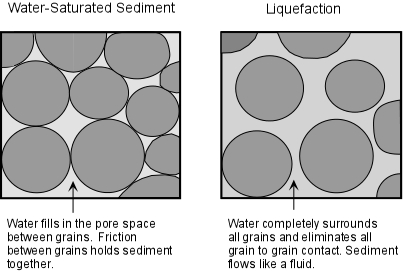
You can demonstrate this process to yourself next time your go the beach. Stand on the sand just after an incoming wave has passed. The sand will easily support your weight and you will not sink very deeply into the sand if you stand still. But, if you start to shake your body while standing on this wet sand, you will notice that the sand begins to flow as a result of liquefaction, and your feet will sink deeper into the sand.
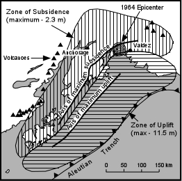
Changes in Ground Level - A secondary or tertiary effect that is caused by faulting. Earthquakes may cause both uplift and subsidence of the land surface. During the 1964 Alaskan Earthquake, some areas were uplifted up to 11.5 meters, while other areas subsided up to 2.3 meters.
Tsunamis - Tsunamis are giant ocean waves that can rapidly travel across oceans, as will be discussed in more detail later. Earthquakes that occur beneath sea level and along coastal areas can generate tsunamis, which can cause damage thousands of kilometers away on the other side of the ocean.
Flooding - Flooding is a secondary effect that may occur due to rupture of human made dams, due to tsunamis, and as a result of ground subsidence after an earthquake.
World Distribution of Earthquakes
The distribution of earthquakes is called seismicity. Seismicity is highest along relatively narrow belts that coincide with plate boundaries (see figure 3.27 in your text). This makes sense, since plate boundaries are zones along which lithospheric plates move relative to one another.
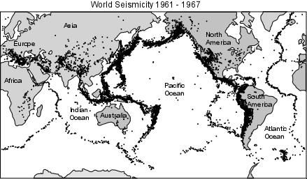
Earthquakes along these zones can be divided into shallow focus earthquakes that have focal depths less than about 100 km and deep focus earthquakes that have focal depths between 100 and 700 km.
Earthquakes at Diverging Plate Boundaries.
Diverging plate boundaries are zones where two plates move away from each other, such as at oceanic ridges. In such areas the lithosphere is in a state of tensional stress and thus normal faults and rift valleys occur. Earthquakes that occur along such boundaries show normal fault motion, have low Richter magnitudes, and tend to be shallow focus earthquakes with focal depths less than about 20 km. Such shallow focal depths indicate that the brittle lithosphere must be relatively thin along these diverging plate boundaries.
Examples - all oceanic ridges, Mid-Atlantic Ridge, East Pacific rise, and continental rift valleys such as the basin and range province of the western U.S. & the East African Rift Valley.
Earthquakes at Transform Fault Boundaries.
Transform fault boundaries are plate boundaries where lithospheric plates slide past one another in a horizontal fashion. The San Andreas Fault of California is one of the longer transform fault boundaries known. Earthquakes along these boundaries show strike-slip motion on the faults and tend to be shallow focus earthquakes with depths usually less than about 100 km. Richter magnitudes can be large.
Examples - San Andreas Fault, California, South Island of New Zealand.
Earthquakes at Converging Plate Boundaries.
Convergent plate boundaries are boundaries where two plates run into each other. Thus, they tend to be zones where compressional stresses are active and thus reverse faults or thrust faults are common.
There are two types of converging plate boundaries.
(1) subduction boundaries, where oceanic lithosphere is pushed beneath either oceanic or continental lithosphere; and
(2) collision boundaries where two plates with continental lithosphere collide.
Subduction boundaries -At subduction boundaries cold oceanic lithosphere is pushed back down into the mantle where two plates converge at an oceanic trench. Because the subducted lithosphere is cold it remains brittle as it descends and thus can fracture under the compressional stress.
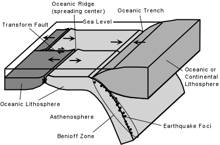
When it fractures, it generates earthquakes that define a zone of earthquakes with increasing focal depths beneath the overriding plate. This zone of earthquakes is called the Benioff Zone. Focal depths of earthquakes in the Benioff Zone can reach down to 700 km.
Examples - Along coasts of South American, Central America, Mexico, Northwestern U.S., Alaska, Japan, Philippines, Caribbean Islands.
Collision boundaries
At collisional boundaries two plates of continental lithosphere collide resulting in fold-thrust mountain belts. Earthquakes occur due to the thrust faulting and range in depth from shallow to about 200 km.
Examples - Along the Himalayan Belt into China, along the Northern edge of the Mediterranean Sea through Black Sea and Caspian Sea into Iraq and Iran.
Intraplate Earthquakes - These are earthquakes that occur in the stable portions of continents that are not near plate boundaries.
Many of them occur as a result of re-activation of ancient faults, although the causes of some intraplate earthquakes are not well understood.
Examples - New Madrid Region, Central U.S., Charleston South Carolina, Along St. Lawrence River - U.S. - Canada Border.