Unconformities, Disconformities and Conformities

Unconformities, Disconformities and Conformities
Conformities,
Disconformities,
Steps in the Formation of a
Disconformity
Unconformities,
Steps in the Formation of an
Unconformity
Conformity
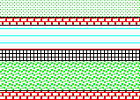
Bedding and contacts parallel. No physical evidence for erosion or deformation. Beds deposited from the bottom up according to the Law of Superposition of Strata. The beds were probably laid down during spurts of deposition followed by intervals when nothing happened -- no sign of disturbance, uplift, or erosion.
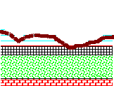
Disconformity
Bedding is parallel on both sides of the contact but evidence shows a break (erosion, uplift) has occurred.In this sketch the break is evident in the erosional relief at the contact and by the clasts of older rocks in the younger strata. In some cases the surface is flat and there are no clasts but there could be subtle signs that weathering has occurred. Some passage of time is needed for the uplift and erosion. Additional time may be represented by any rocks that were once present but removed by the erosion.
Steps in the Formation of a Disconformity
Step #1
Deposit a series of conformable beds. Following the Law of SUPERPOSITION OF STRATA the layer on the bottom was deposited first and the sequence was deposited from the bottom up. Each different pattern represents a different kind of sedimentary rock -- except for the fact that the rocks were deposited underwater, we don't need to bother with the rock names for this exercise.
Step#2
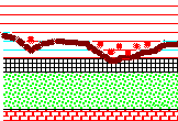
In this step the beds are uplifted. Erosion occurs at the top of the picture. Material is removed from the top down and carried away from the picture area. Uplift keeps lifting the pile into the erosion zone. Count the beds in picture #2 and compare with picture #1. Note that several of the younger beds have been lost. The erosion surface is shown in dark brown, In picture #2 this surface is irregular and shows hills and stream valleys in cross section. Such irregularity is common but there are cases where erosion has produced a flat surface. Soil often develops below the erosion surface and some features of the soil may be preserved in the rock record -- leaving clues by which geologists can recognize old erosion surfaces.
Step #3
In STEP #3 deposition resumes. Maybe the water rose or maybe the land dropped -- you can't tell which from what is shown in these pictures. New sediments shown in red at the top of the picture bury the old erosion surface and the strata below it. The valleys are filled first and may contain clasts (the red spots) of the older rocks. Soon even the hills are under water and the deposits are flatlying.
The Disconformity shows physical signs that uplift and erosion has occurred but bedding is parallel on both sides of the contact.
Angular unconformity
Bedding below the contact is NOT parallel to bedding above the contact. This indicates that deformation of the older beds occurred before the upper beds were deposited. In this sketch the deformation consists of tilting and faulting. Either could occur by itself or the beds could be folded. Examples from Grand Canyon U.S.A.
Point Imperial
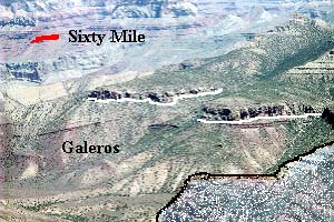
Point Imperial is about the highest point on the North Rim of Grand Canyon. This view looks to the east across a broad stretch of the Precambrian Chuar Group. The unconformity below the Cambrian Tapeats is traced in white.
The Chuar Group is divided from top to bottom into the Sixty Mile, Kwagunt, and Galeros Formations. A small remnant of Sixty Mile Fm. atop Nankoweap Butte is
marked in red. These beds dip about 15 degrees to the north and several prominent beds can be seen angling up towards the unconformity.
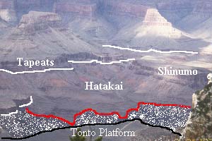
The angular unconformity below the Tapeats is traced with a white line. Below it are the Shinumo sandstone, Hakatai shale, and Bass limestone of the Precambrian Unkar Group. You can see these dipping beds angling up to the unconformity. The resistant Shinumo sandstone stood as an island in the sea when the Tapeats was deposited. The red line marks a second, older angular unconformity. The Vishnu schist and gneiss below this unconformity were deposited as sediments almost 2,000,000,000 years ago. Eventually these rocks found themselves deep in the roots of a mountain range and were metamorposed to schist and gneiss. Millions of years were then needed to erode the mountains and lift these rocks back to the surface.
Steps in the Formation of an Angular Unconformity
The development of an unconformity is shown in the sketches below:
STEP #1
Deposit a series of conformable beds. Following the Law of SUPERPOSITION OF STRATA the layer on the bottom was deposited first and the sequence was deposited from the bottom up. Each different pattern represents a different kind of sedimentary rock -- except for the fact that the rocks were deposited underwater, we don't need to bother with the rock names for this exercise.
STEP #2 .
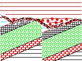
In this step deposition stops and the beds are tilted and faulted. The picture shown in the sketch doesn't let me tell whether the faulting occurred before the tilting or vice versa.
STEP #3
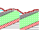
In this step the faulted, tilted beds are uplifted. Erosion occurs at the top of the picture. Material is removed from the top down and carried away from the picture area. Uplift keeps lifting the pile into the erosion zone at the earth's surface. Count the beds in picture #3 and compare with picture #1. Note that several of the younger beds have been lost.
The erosion surface is shown in dark brown, In picture #3 this surface is irregular and shows hills and stream valleys in cross section. Such irregularity is common but there are cases where erosion has produced a flat surface. Soil often develops below the erosion surface and some features of the soil may be preserved in the rock record -- leaving clues by which geologists can recognize old erosion surfaces.
The presence of erosion strongly implies that uplift occurred. It is possible that the uplift began as early as Step #2 but you can't say for certain from the evidence in these pictures.
STEP #4
In STEP #4 deposition resumes. Maybe the water rose or maybe the land dropped -- you can't tell which from what is shown in these pictures. New sediments shown in red at the top of the picture bury the old erosion surface and the strata below it. The valleys are filled first and may contain clasts (the red spots) of the older rocks. Soon even the hills are under water and the deposits are flatlying.