Volcanoes / Volcanic Hazards

Volcanoes / Volcanic Hazards
adapted to html from notes by Cliff Ollier , Stephen A. Nelson and other sources...
see also... Volcanic / Astronomy Terms
(Glossary)
Basic Lava Volcanoes
Lava shields
Lava dome
Lava cones
Lava mounds
Lava disc
Acid Lava Volcanoes
Cumulo-domes
Plug domes
Spines
Pyroclastic Volcanoes
Scoria cone
Scoria mound
Nested scoria cones
Littoral cones
Maars (tuff rings)
Mixed Eruption Volcanoes
Strato-Volcanoes
Miscellaneous volcanoes
Composite volcanoes
Parasitic
cones (also called adventive cones and secondary cones)
Multiple cones
Diatreme
Primary Effects of Volcanism
Violent Eruptions and
Pyroclastic Activity
Poisonous Gas Emissions
Secondary and
Tertiary Effects of Volcanism
Beneficial Aspects of Volcanism
Predicting Volcanic Eruptions
Vesuvius, 79 A.D.
Mt. Pelée, Martinique, 1902
Mt. St. Helens, 1980
In popular imagination volcanoes are always symmetrical cones like Fujiyama, but in reality volcanoes vary widely in shape, size, and composition. As a first classification we shall consider the common forms of volcanoe associated with basic lava, acid lava, scoria eruption and mixed eruption.
Basic Lava Volcanoes
Basic lavas are characteristically very fluid, so spread easily and give rise typically to volcanoes of low gradient.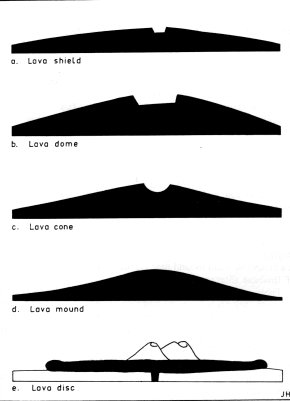
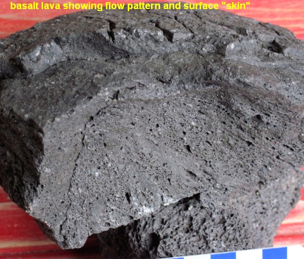 Basalt lava
Basalt Lava flows at about 950-1200 degrees celsius. It can move at about a walking pace. The wrinkled surface skin is often glassy as the released water steam often supercools the surface into glass. The degree of devitrification of the glass surface can act as a rough guide to the relative age of the flow. A basalt flow rapidly covered by a thick layer of insulating tuff (ash) is able to cool slowly It shrinks evenly to form columnar "stop-sign-like shapes" similar to mudcracks. Famous examples include the Giant's Causeway in Ireland and the Devil's Tower in Wyoming USA.
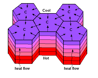
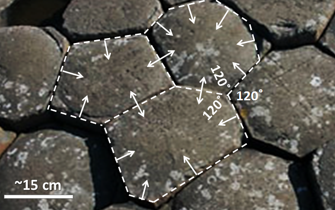
Figure 4: Basaltic Cone types
Lava shields

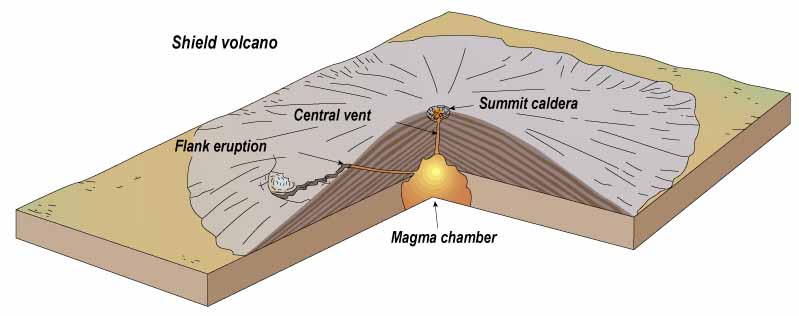
A succession of wide sheets of volcanic rock, built by repeated outpourings of basaltic lava, can pile up to produce huge 'shields' with gentle slopes (less than 7º) and convex outlines. The Hawaiian islands are the classic example. Mauna Loa, the largest island, rises 19,000 m above its sea-floor base, which is 109 km wide, and projects over 4000 m above the sea. Shields of this size are made up of a number of separate volcanoes; for instance Kilauea and Hualalai are mere flank volcanoes on Mauna Loa. Volcanic masses such as the island of Hawaii, formed by the overlapping of a group of shield volcanoes, may be termed volcanic shield-clusters. Parasitic cones, flank eruptions, and fissure eruptions are commonly associated with shield volcanoes. 'Shield volcanoe' is a less exact term that usually refers to a lava shield, but may be used for a large strato-volcanoe or volcanic complex.
Lava dome

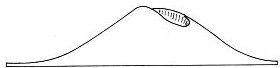
A smaller-scale volcanoe that erupts liquid lava may produce a convex dome rather than a shield. Any of the individual peaks on Hawaii, such as Mauna Kea, may be regarded as lava domes. The distinction between size used here is not standard practice and many authors use shield and dome interchangeably.
Lava cones

Central eruption on a still smaller scale may give rise to simple straight-sided cones built of successive lava flows, such as Mt Hamilton, Victoria. These usually have flanks of low angle (7º or less), but some examples are much steeper. Beerenberg on the Arctic island of Jan Mayen, for example, consists of a broad basalt lava dome some 15-24 km in diameter at sea level, on the crest of which is a lava cone with steep 450 slopes, some 5 km in diameter and 750 m high (Fitch, 1964). In the Victorian volcanic province a final stage of scoria eruption often obliterates lava cones formed earlier. In Iceland a rim of scoria round the crater is charactenstic.
The Kolotta Dyngja, a typical Icelandic volcanoe, rises to a height of 460 m with an average slope of 70, approaching 80 towards the summit. The volcanoe has a diameter of 5 km and the crater a diameter of 550 m. A ring of scoria about 15 m high surrounds the crater, and has slopes of up to 30 degrees.
Lava mounds

Some basaltic volcanoes have no sign of a crater, but are gently sloping mounds, such as Mt Cotterill, Victoria. These extinct volcanoes may owe their shape partly to erosion, although they probably never had very pronounced craters but had lava welling right to the brim before solidification. Such volcanoes, distinguished from cones by their lack of crater, may be termed lava mounds by analogy with scoria mounds.
Lava disc

In Victoria there are a few anomalous volcanoes which have been described as lava discs. They are made of basalt, and display jointing perpendicular to the lava skin on both the upper surface and the sides. The smallest one, Lawaluk, has the form of a steep-edged, flat-topped disc of basalt. Mondilibi is probably of the same type, and the main lava sheet within the ring barrier of Mt Porndon appears to be a similar feature though larger (3 km in diameter). These hills appear to be made by eruption of single flows that develop a tough skin and spread out from the centre without breaking the skin, in the manner of a water-filled balloon collapsing into a disc.
Acid Lava volcanoes
Acid igneous rocks are generally very viscous, and if they do not explode their lack of flow gives rise to a number of distinctive landforms

Figure 5: Acid Lava forms
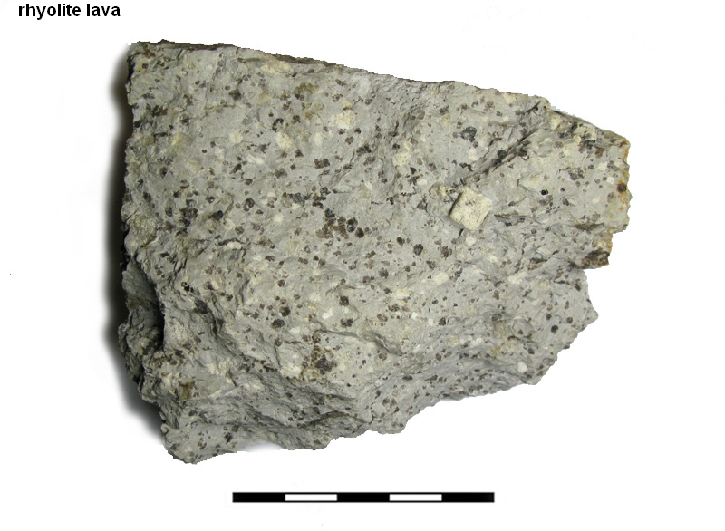
Rhyolite lava consists of a silica rich sacchariodal (sugar size) fine grained grey matrix with a larger phenochrysts of quartz(30%), sanidine(40%) and plagioclase feldspar(30%). At temp[eratyures as low as 560-700 degrees celsius, a rhyolite lava flow creeps slowly and takes on the appearance of a "blocky slow motion avalanche". Often the quartz crystals ore partially resorbed and rounded giving the rhyolite it's characteristic "quartz-eyes". Rhyolite is "sti]cky" and "chunky" and rathe than flow may mound up in "domes" . The measurement of the rate of expansion of a "dome" may be useful in roughly predicting a volcanic explosion like Mt. St. Helens.
Cumulo-domes
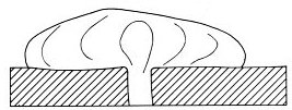
When viscous lava is extruded, it sags and spreads into convex dome-like bodies called cumulo-domes. These may be almost independent, or may be associated with and partly intrusive into previously deposited pyroclasts. The main part of Lassen Peak, California, is a large-scale example, rising 800 m above pyroclastics and having a diameter of 2.5 km.
In the Mullaley district of New South Wales there are two simple cumulo-volcanoes with the form of domes and three similar structures that are breached by trachyte (Wilshire and Standard, 1963) Mt Macedon, Hanging Rock, and Brocks Monument, Victoria, are examples of fairly small cumulo-domes.
In the Central Volcanic Region of the North Island of New Zealand there are many hyolite domes, akin to cumulo-domes, but with more mobile flows or coulees on their flanks. These appear to erupt in the late stage of a volcanic cycle after vast ignimbrite flows and caldera formation.
Sometimes several cumulo-domes may coalesce.
Tauhara in New Zealand is a multiple volcanoe of late Pleistocene age consisting of five coalescing dacite cumulo-domes. Internal flow structures suggest that each dome was formed from lava continuously extruded, but each had a separate vent.
The Tarawera Rift explosion of 1886 exposed excellent sections through a number of domes, enabling a better interpretation of internal structure than is usually possible. There is well-developed circular jointing at the centre of domes, becoming vertical towards the edge and in the coulees. The tops of both domes and coulees are very irregular due to fissuring.
The puys or volcanic hills of the Puy-de-Dome landscape of Auvergne are typically scoria cones with craters, but some, such as the craterless Grand Sarcoui, are trachytic cumulo-domes, and the term puy is occasionally and unfortunately used to mean cumulo-dome.
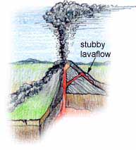
Plug domes
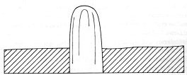
In its most viscous form, the magma extruded from a vent may be so rigid that it moves up like a piston, producing a roughly cylindrical body known as a plug dome. [In American usage plug dome may refer to what are here called cumulo-domes.] In New Zealand, Mt Edgecumbe is an andesite volcanoe that was apparently extruded through a jagged orifice, for it has grooves on the side and top that are not due to erosion, but are giant scratches. The Pitons of Carbet, Martinique, are thought to be plug domes, and Merapi, Indonesia, is an active volcanoe which builds successive plug domes that are explosively destroyed.
Plug domes can grow rapidly, but during growth they are shattered by explosions and broken by uneven growth, and the accumulation of broken spines and extrusion ridges causes many plug domes to be covered by a jumble of debris, which make a scree-like deposit around the flanks with rocks piled up at their angle of rest.
Spines
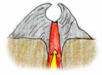
Whereas plug domes are large bodies of nearly mountain size, smaller-scale extrusion of very rigid lava, through chinks in the cracked skin of plug domes or cumulo-domes, gives rise to spines. The spine of Mont Pelée, Martinique, which was produced after the catastrophic eruption of 1902, reached a height of over 300 m, but was rapidly eroded. At one stage it grew 13 m in a day. Spines are frequently irregular in shape, and are not extruded uniformly as cylindrical pillars. A spine on Santa Maria, Guatemala, that grew between 1922 and 1925, reached a maximum size of 500m high and 1300m across the base.Pyroclastic volcanoes
When explosively produced fragments of lava fall around a volcanic vent they build up a heap of debris, the slope of which depends on the angle of rest of the fragments concerned (Figure 8). Fine particles have lower slopes than coarse ones, and as the coarser fragments tend to accumulate near the vent, beautiful concave slopes are formed, like those of Fujiyama and Mt Egmont.

8: Scoria volcanic types
 Scoria is full of holes made by
expanding gases and steam
Scoria is full of holes made by
expanding gases and steamScoria cone
The ideal scoria cone is single, steep, with straight or gently concave sides, and with a crater at the top. Mt Elephant, Victoria, 240 m high, is a good example. The even height of the crater rim often causes scoria cones to appear flat4opped when viewed from a distance. Scoria cones may be built very rapidly. Monte Nuovo near Naples, Italy, was built to a height of 130 m in a single eruption lasting a few days in 1538. Barcena, on the island of San Benedicto, Mexico, built a cone of 300m in twelve days in 1952.
In the last stages of eruption basaltic magma tends to build up scoria cones. Thus in Victoria there are far more scoria cones than other types of volcanoe, though the province as a whole is dominated by flows of basic lava.
Scoria mound

Some scoria volcanoes have no apparent crater and may be termed scoria mounds to distinguish them from normal scoria cones. The Anakies, Victoria, are examples.
Nested scoria cones
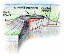
Scoria cones are frequently produced as the last phase of an eruption on the site of larger volcanoes of other type. When they are in the centre of a large crater or caldera they are called nested cones. The V-sectioned trough between the inner cone and the crater wall is called a fosse.
Littoral cones
When aa lava reaches the sea it explodes and the ejecta pile up to form a cone up to 100 m high and 1 km in diameter. There is often a double hill, one hill built on each side of the lava stream (Wentworth and Macdonald, 1953).
Maars (tuff rings)

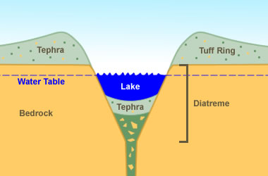
Maar - the old landscape / water table is sealed by a layer of rock, rising magma heats the water table but the steam has no escape, pressure builds until it is released in a massive steam explosion
Maars are landforms caused by volcanic explosion and consist of a crater which extends below general ground level and is considerably wider than deep, and a surrounding rim constructed of material ejected from the crater. The rim consists of pyroclastic material, either igneous or comminuted bedrock, and is often markedly asymmetrical, with greater deposition on the downwind side of the crater. The rim deposit is also asymmetrical in cross section, with a steep side towards the crater, and a gentle slope (commonly 40º or less) away from the crater, parallel to the bedding of the pyroclastics. The craters have a diameter often about 1 km and the rims are commonly less than 50 m high, although they may reach 100 m. Maars are usually associated with basaltic igneous activity, but andesitic maars are known in Chile.
Mixed Eruption volcanoes
In many volcanoes there is a mixture of lava and fragmental deposits.
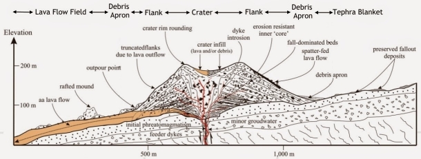
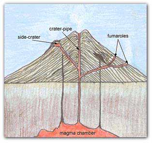
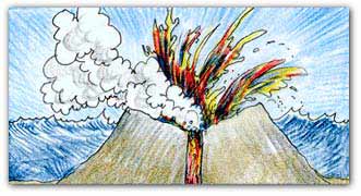
Strato-volcanoes
Many of the world's great volcanoes, such as Vesuvius, Fujiyama, Egmont, and many others, are strato-volcanoes, with both lava flows and pyroclastic deposits. Many of these have erupted over a long period, and indeed the strato-volcanoe is the commonest form developed by long-lived central volcanoes. The cones become gullied by erosion and lava flows commonly follow such gullies. New gullies then form on the edges of flows, and so on. Scoria cones are built around the top of the volcanoe and pyroclastic flow and fall deposits may have a wide distribution on the flanks. Ngauruhoe, New Zealand, is a typical strato-volcanoe, almost perfectly conical and about 1000 m high. The slopes are about 30 degrees steep and the crater is about 400 m across. The highest point on the rim is to the east, possibly because of the prevailing westerly wind. Young aa lava flows have reached the base on all sides except the east. Some strato-volcanoes are isolated, but many occur in groups. In McMurdo Sound, Antarctica, for instance, the large young strato-volcanoes, Mts Erebus (altitude 3700 m), Bird, Terra Nova, and Terror coalesce to form Ross Island.
Hekla, Iceland, is intermediate in many respects between a typical Icelandic shield volcanoe and a strato-volcanoe such as Vesuvius. It has been built by repeated eruptions from a fissure, often with several craters active at the same time.
Miscellaneous volcanoes
Composite volcanoes
This term in a strict sense refers to those volcanoes which have a mixture of lava and scoria forms, but not in a simple layered sequence. Mt Rouse, Victoria, is an example, with an elongate crater in a scoria hill and with a smaller and more distinct crater with a basalt rim on the south. The composite Mt Porndon, Victoria, has a large basalt disc with a diameter of about 3 km, in the centre of which are a number of scoria cones and mounds. Staughtons Hill, Victoria, consists of a maar, a scoria cone, and a basalt-rimmed separate crater. Most composite hills appear to consist of individual hills which are genetically related, but it is possible that some, such as Staughtons Hill, are due to accidental superimposition of unrelated eruption points of different ages.
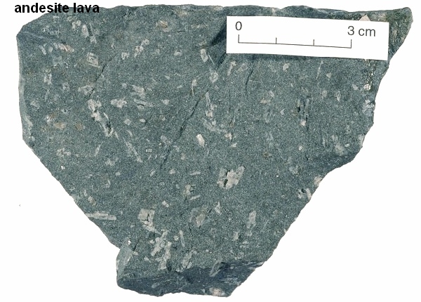
Andesite lava is the result of two-stage cooling. First the lava cools slowly and crystals of plagioclase feldspar begin to form. It then is cooled quickly to form a very fine grained grey matrix. Chemically it lies between basalt and rhyolite compositions. The lava is viscous and slow moving with a temperature range of about 750 - 950 degrees celsius.
Parasitic cones (also called adventive cones and secondary cones)
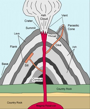
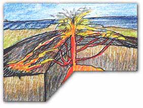
When a volcanoe becomes very high, very great pressure is required for the rising lava to reach the summit crater. It is sometimes possible for the lava to find an easier route to the surface, and erupt on the flanks of the main volcanoe. Once such an eruption has taken place, the solidified lava in the conduit plugs that outlet, and in succeeding eruption another opening must be made. In this manner large volcanoe comes to have many small parasitic cones on its flanks. Mt Etna, Sicily, with over two hundred parasitic cones and over eight hundred small mounds of lava known as boccas, is the finest example. Here each new series of eruptions occurs along a rift, and succeeding new cones appear higher and higher up the fissure until it is sealed.
Multiple cones
In some areas, as, for instance, on the volcanic plains of Victoria, a number of scoria cones are built very close together. The general mechanism appears to be the same as for parasitic cones, that is the first cone blocks the vent, and the second one occurs on a new vent close by. The difference here is that no cones grow to any great size, and all the separate cones tend to be of about the same size; that is there is no main volcanoe with parasites, but a series of equal volcanoes. These may be called multiple cones.
Diatreme
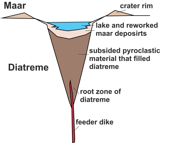
A diatreme is formed when hot gases from a volcanoe burn an exit point through a weak zone on the surrounding rock. This rock may or may not be volcanic.
The resultant "carrot shaped" vent often launched debris into the air which falls back into the hole to form a "breccia pipe". Diatremes are noted for the relatively smooth walls formed by the jet of gas.
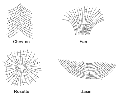
Joint Patterns around Volcanoes
Volcanic Hazards/Case Studies
adapted to html based on notes of Stephen A. Nelson Primary Effects of Volcanism
Violent Eruptions and
Pyroclastic Activity
Poisonous Gas Emissions
Secondary and
Tertiary Effects of Volcanism
Beneficial Aspects of Volcanism
Predicting Volcanic Eruptions
Vesuvius, 79 A.D.
Mt. Pelée, Martinique,
1902
Mt. St. Helens, 1980
Primary Effects of Volcanism
Lava Flows
Lava flows are common in Hawaiian and Strombolian type of eruptions, the least explosive. Although lava flows have been known to travel as fast as 64 km/hr, most are slower and give people time to move out of the way.
Thus, in general, lava flows are most damaging to property, as they can destroy anything in their path.
Control of lava flows has been attempted with limited success by bombing flow fronts to attempt to divert the flow, and by spraying with water to cool the flow. The latter is credited with saving the fishing harbor during a 1973 eruption of Heimaey in Iceland.
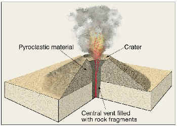
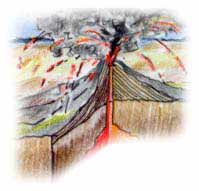
Violent Eruptions and Pyroclastic Activity
Pyroclastic activity is one of the most dangerous aspects of volcanism. Hot pyroclastic flows cause death by suffocation and burning.
They can travel so rapidly that few humans can escape.
Lateral blasts knock down anything in their path, can drive flying debris through trees.
Tephra falls can cause the collapse of roofs and can affect areas far from the eruption. Although tephra falls blanket an area like snow, they are far more destructive because tephra deposits have a density more than twice that of snow and tephra deposits do not melt like snow.
Tephra falls destroy vegetation, including crops, and can kill livestock that eat the ash covered vegetation.
Tephra falls can cause loss of agricultural activity for years after an eruption, a secondary or tertiary effect.
Poisonous Gas Emissions
volcanoes emit gases that are often poisonous to living organisms.
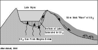
Among these poisonous gases are: Hydrogen Chloride (HCl), Hydrogen Sulfide (H2S), Hydrogen Flouride (HF), and Carbon Dioxide (CO2). In 1984, CO2 gas escaping from the bottom of Lake Monoun, a crater lake in the African country of Cameroon, killed 37 people. In 1986 an even larger CO2 gas emission from Lake Nyos in Cameroon killed more than 1700 people and 3000 cattle.
Secondary and Tertiary Effects of Volcanism
Mudflows (Lahars)
volcanoes can emit voluminous quantities of loose, unconsolidated tephra which become deposited on the landscape.
Such loose deposits are subject to rapid removal if they are exposed to a source of water. The source of water can be derived by melting of snow or ice during the eruption, emptying of crater lakes during an eruption, or rainfall that takes place any time with no eruption.
Thus, mudflows can both accompany an eruption and occur many years after an eruption.
Mudflows are a mixture of water and sediment, they move rapidly down slope along existing stream valleys, although they may easily top banks and flood out into surrounding areas.
They have properties that vary between thick water and wet concrete, and can remove anything in their paths like bridges, highways, houses, etc.
During the Mt. St. Helens eruption of May 18, 1980, mudflows were generated as a result of snow melt on the volcanoe itself, and deposition of tephra in streams surrounding the mountain.

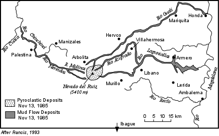
On November 13, 1985 a mudflow generated by a small eruption on Nevado del Ruiz volcanoe in Columbia flowed down slope and devastated the town of Armero, 50 km east of the volcanoe and built on prior mudflow deposits.
The town had several hours of warning from villages higher up slope, but these warnings were ignored, and 23,000 people died in the mudflow that engulfed the town.
Debris Avalanches and Debris Flows
Volcanic mountains tend to become oversteepened as a result of the addition of new material over time as well due to inflation of the mountain as magma intrudes. Oversteepened slopes may become gravitationally unstable, leading to a sudden slope failure that results in landslides, debris slides or debris avalanches.
We will cover these types of hazards in more detail later in the course and in the next lecture.
During the May 18, 1980 eruption of Mt. St. Helens, Washington, a debris avalanche was triggered by a magnitude 5.0 earthquake.
The avalanche removed the upper 500 m of the mountain, and flowed into the Spirit Lake, raising its level about 40 m.
It then moved to the west filling the upper reaches of the North Fork of the Toutle River valley (see map above).
Debris avalanches, landslides, and debris flows do not necessarily occur accompanied by a volcanic eruption.
There are documented cases of such occurrences where no new magma has been erupted.
Flooding
Drainage systems can become blocked by deposition of pyroclastic flows and lava flows.
Such blockage may create a temporary dam that could eventually fill with water and fail resulting in floods downstream from the natural dam. volcanoes in cold climates can melt snow and glacial ice, rapidly releasing water into the drainage system and possibly causing floods. Jokaulhlaups occur when heating of a glacier results in rapid outburst of water from the meleting glacier.
Tsunamis
Debris avalanche events, landslides, caldera collapse events, and pyroclastic flows entering a body of water may generate tsunamis (more detail on tsunamis will found later in the course). During the 1883 eruption of Krakatua volcanoe, in the straits of Sunda between Java and Sumatra, several tsunamis were generated by pyroclastic flows entering the sea and by collapse accompanying caldera formation.
The tsunamis killed about 36,400 people, some as far away from the volcanoe as 200 km.
Volcanic Earthquakes and Tremors
Earthquakes usually precede and accompany volcanic eruptions, as magma intrudes and moves within the volcanoe. Although most volcanic earthquakes are small, some are large enough to cause damage in the area immediately surrounding the volcanoe, and some are large enough to trigger landslides and debris avalanches, such as in the case of Mount St. Helens. Volcanic Tremor (also called harmonic tremor) is a type of continuous rhythmic shaking of the ground that is generated by magma moving underground.
Atmospheric Effects
Since large quantities of tephra and volcanic gases can be injected into the atmosphere, volcanism can have a short-term effect on climate. Volcanic ash can cause reflection of solar radiation, and thus can cause the temperatures to be cooler for several years after a large eruption.
The 1860 eruption of Tambora volcanoe in Indonesia, was the largest in recorded history.
The year following the Tambora eruption (1861) was called the "year without summer".
Snow fell in New England in July.
Volcanic gases like SO2 also reflect solar radiation.
Eruptions in 1981 at El Chichón volcanoe, Mexico, and 1991 at Pinatubo, Philippines, ejected large quantities of SO2 into the atmosphere.
The effects of the El Chichón eruption were masked by a strong El Niño in the year following the eruption, but Pinatubo caused a lowering of average temperature by about 1oC for two years following the eruption.
Volcanic gases like CO2
are greenhouse gases which help keep heat in the atmosphere.
During the mid-Cretaceous (about 90 to 120 million years ago) the CO2 content of the atmosphere was about
15 times higher than present.
This is thought to have been caused by voluminous eruptions of basaltic magma on the sea floor.
Average temperatures were likewise about 10 to 12oC warmer than present.
Famine and Disease
As noted above, tephra falls can cause extensive crop damage and kill livestock.
This can lead to famine. Displacement of human populations, breakdown of sewerage and water systems, cut off of other normal services can lead to disease for years after an eruption, especially if the infrastructure is not in place to provide for rapid relief and recovery.
Beneficial Aspects of Volcanism
Since this course concentrates on the damaging effects of volcanism, we won't spend too much time on the topic of the beneficial aspects of volcanism.
We note here, that volcanism throughout Earth history is responsible for outgasing of the Earth to help produce both the atmosphere and hydrosphere.
Volcanism helps renew the soil, and soils around active volcanoes are some the richest on Earth.
Hydrothermal processes associated with volcanism produce rich ore deposits, and the heat rising around magma bodies can sometimes be tapped to produce geothermal energy.
Predicting Volcanic Eruptions
- Active volcanoe
- An active volcanoe to volcanoelogists is a volcanoe that has shown eruptive activity within recorded history.
Thus an active volcanoe need not be be in eruption to be considered active.
Currently there are about 600 volcanoes on Earth considered to be active volcanoes. Each year 50 to 60 of volcanoes actually erupt. - Extinct volcanoe
An extinct volcanoe is a volcanoe that has not shown any historic activity, is usually deeply eroded, and shows no signs of recent activity.
How old must a volcanoe be to be considered extinct depends to a large degree on past activity.
For example, Yellowstone Caldera is about 600,000 years old and is deeply eroded.
But fumorolic activity, hot springs, and geysers all point to the fact that magma still exists beneath the surface.
Thus, Yellowstone Caldera is not considered extinct. Other volcanoes that are deeply eroded, smaller, and much younger than Yellowstone, that show no hydrothermal activity may be considered extinct. - Dormant volcanoe
A dormant volcanoe (sleeping volcanoe) is somewhere between active and extinct.
A dormant volcanoe is one that has not shown eruptive activity within recorded history, but shows geologic evidence of activity within the geologic recent past.
Because the lifetime of a volcanoe may be on the order of a million years, dormant volcanoes can become active volcanoes all of sudden.
These are perhaps the most dangerous volcanoes because people living in the vicinity of a dormant volcanoe may not understand the concept of geologic time, and there is no written record of activity.
These people are sometimes difficult to convince when a dormant volcanoe shows signs of renewed activity. Yellowstone Caldera would be considered a dormant volcanoe/ul
Mount St. Helens was a considered a dormant volcanoe, having not erupted for 123 years, before its reawakening in 1980.
Mount Pinatubo in the Philippines had been dormant for over 400 years before its eruption in 1991. Mount Vesuvius, near Naples, Italy was considered an extinct volcanoe prior to its devastating eruption of 79 A.D.
Long - Term Forecasting and Volcanic Hazards Studies
Studies of the geologic history of a volcanoe are generally necessary to make an assessment of the types of hazards posed by the volcanoe and the frequency at which these types of hazards have occurred in the past. Once this information is available, geologists can then make forecasts concerning what areas surrounding a volcanoe would be subject to the various kinds of activity should they occur in a future eruption, and also make forecasts about the long - term likelihood or probability of a volcanic eruption in the area.
During such studies, geologists examine sequences of layered deposits and lava flows.
Armed with knowledge about the characteristics of deposits left by various types of eruptions, the past behavior of a volcanoe can be determined.
Using radiometric age dating of the deposits the past frequency of events can be determined.
This information is then combined with knowledge about the present surface aspects of the volcanoe to make volcanic hazards maps which can aid other scientists, public officials, and the public at large to plan for evacuations, rescue and recovery in the event that short-term prediction suggests another eruption. Such hazards maps delineate zones of danger expected from the hazards discussed above: lava flows, pyroclastic flows, tephra falls, mudflows, floods, etc.
Short - Term Prediction based on Volcanic Monitoring Short - term prediction of volcanic eruptions involves monitoring the volcanoe to determine when magma is approaching the surface and monitoring for precursor events that often signal a forthcoming eruption.
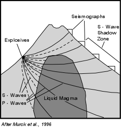
Seismic Exploration and Monitoring
Since seismic waves are generated by both earthquakes and explosions, and since S-waves cannot pass through liquids, arrays of seismographs can be placed around a volcanoe and small explosions can be set off to generate seismic waves.
If a magma body exists beneath the volcanoe, then there will be zone were no S-waves arrive (an S-wave shadow zone) that can be detected.
Monitoring the movement of the S-wave shadow zone can delineate the position and movement of the magma body.
As noted above, as magma moves and deforms rocks it may be responsible for the generation of earthquakes. Thus, there is usually an increase in seismic activity prior to a volcanic eruption.
Focal depths of these precursor earthquakes may change with time, and if so, the movement of magma can sometimes be tracked.
In addition, volcanic tremor, as noted above, can also be indication that magma is moving below the surface.
Changes in Magnetic Field
Rocks contain minerals such as magnetite that are magnetic.
Such magnetic minerals generate a magnetic field.
However, above a temperature called the Curie Temperature, these magnetic minerals show no magnetism.
Thus, if a magma body enters a volcanoe, the body itself will show no magnetism, and if it heats the surrounding rocks to temperatures greater than the Curie Temperature (about 500oC for magnetite) the magnetic field over the volcanoe will be reduced.
Thus, by measuring changes in the magnetic field, the movement of magma can sometimes be tracked.
Changes in Electrical Resistivity
Rocks have resistance to the flow of electrical current which is highly dependent on temperature and water content.
As magma moves into a volcanoe this electrical resistivity will decrease.
Making measurements of the electrical resistivity by placing electrodes into the ground, may allow tracking of the movement of magma.
Ground Deformation
As magma moves into a volcanoe, the structure may inflate.
This will cause deformation of the ground which can be monitored.
Instruments like tilt meters measure changes in the angle of the Earth's surface which are measured in microradians
0.00018o.
Other instruments track changes in distance between several points on the ground to monitor deformation.
Changes in Groundwater System
As magma enters a volcanoe it may cause changes in the groundwater system, causing the water table to rise or fall and causing the temperature of the water to increase.
By monitoring the depth to the water table in wells and the temperature of well water, spring water, or fumaroles, changes can be detected that may signify a change in the behavior of the volcanic system.
Changes in Heat Flow
Heat is everywhere flowing out of the surface of the Earth.
As magma approaches the surface or as the temperature of groundwater increases, the amount of surface heat flow will increase. Although these changes may be small they be measured using infrared remote sensing.
Changes in Gas Compositions
The composition of gases emitted from volcanic vents and fumaroles often changes just prior to an eruption. In general, increases in the proportions of hydrogen chloride (HCl) and sulfur dioxide (SO2) are seen to increase relative to the proportion of water vapor.
In general, no single event can be used to predict a volcanic eruption, and thus many events are usually monitored so that taken in total, an eruption can often be predicted. Still, each volcanoe behaves somewhat differently, and until patterns are recognized for an individual volcanoe, predictions vary in their reliability. Furthermore, sometimes a volcanoe can erupt with no precursor events at all.
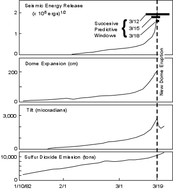
After the catastrophic eruption of Mount St. Helens on May 18, 1980, a volcanic dome began to grow in the crater. Growth of this dome occurred sporadically, and sometimes small eruptions occurred from the dome.
After several years of dedicated monitoring, scientists are now able to predict with increasing accuracy eruptions from this dome.
An example is shown in the graphs, modified from figure 4.3 in your text.
In the weeks prior to an eruption on March 19, 1982, the amount of seismic energy released increased, the amount dome expansion increased, tilt increased, and SO2 emissions increased prior to the event.
Beginning on March 12, a prediction was made that an eruption would be likely within the next 10 days.
On March 15, the prediction was narrowed to likely within 4 days, and on March 18 scientists predicted that an eruption would occur within the next two days.
On March 19 the eruption did occur.
Note that eruption predictions such as in this example are only possible if constant monitoring of a volcanoe takes place.
Monitoring is an expensive endeavor, and not all active or potentially active volcanoes are monitored.
Still, if people living around volcanoes are aware of some of the precursor phenomena that occur, they may be able to communicate their findings of anomalous events to scientists who can begin monitoring on a regular basis and help prevent a pending disaster.
Vesuvius, 79 A.D.
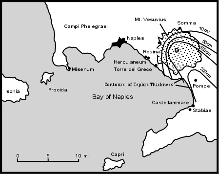
Mount Vesuvius is located to the southeast of Naples, Italy along the Bay of Naples.
Prior to the catastrophic eruption of 79 A.D. Vesuvius was considered an extinct volcanoe by the inhabitants of the area, who were flourishing at the height of the Roman Empire.
The area northwest of Naples, known as the Phelegrean Fields, was known to be an active volcanic area, however. Nevertheless, when earthquakes became frequent in the Vesuvius area in 62 A.D., they caused no alarm because earthquakes were quite common throughout Italy.
What we know of the eruption that took place in 79 A.D. comes from two different sources:
(1) Two letters written by the Pliny the Younger, the nephew of Caius Plinius (Pliny the Elder), to the historian Tacitus concerning the death of his uncle.
Pliny the Elder was an admiral in the Roman navy and well known in his time.
(2) Information from geological and archeological studies that have examined the area around Vesuvius.
We start with the account given by Pliny the Younger in his letters to Tacitus. About 1 P.M. on August 24, 79 A.D. the Plinys were in Misenum, about 30 km across the Bay of Naples from Vesuvius.
A large cloud appeared above the volcanoe, growing rapidly, rising many thousands of meters and spreading out laterally in the atmosphere.
Pliny the Younger states that the cloud had the shape of a Mediterranean pine tree, with a narrow trunk at the base, spreading out like branches above.
Pliny the Elder was curious about the cloud and began to plan a trip across the bay to investigate. Before he could get his ship ready, he received word from people living closer to Vesuvius that people needed help, and his investigative mission became instead a rescue mission.
He organized his fleet and set sail with the intention of rescuing people living near the base of the volcanoe at Torre del Greco.
As he crossed the bay his ship was showered by hot ashes and pumice which accumulated on the deck.
He soon found it was impossible to make the rescue attempt and he turned in the direction of the wind and instead landed at Stabiae, to the south of Vesuvius.
At Stabiae, conditions were still mild and he encountered his friend Pomponianus who was trying to escape to the sea, but the winds were not favorable.
In order to reassure Pomponianus that there was no danger, Pliny went to the local baths and sat down for a meal. As night came, Pliny retired for several hours of sleep.
During his sleep tephra began piling up in the courtyard of the house and earthquakes and loud explosions occurred in the area of Vesuvius.
Pliny awakened by the trembling and loud noises and conferred with Pomponianus.
They decided that there best escape was to go to the shore and try to leave by ship.
They tied pillows to their heads for safety from the falling pumice, but darkness enveloped the area as a result of the falling tephra, and it remained dark even after the sun should have come up.
They eventually made it to the shore, but found that the wind was not blowing in a direction favorable to sail away from the area.
Suddenly Pliny the Elder began to feel poorly.
He laid down on a cloth near the shore and asked for water twice.
Then sulfurous fumes descended on the area making staying put an unpleasant experience.
Pliny rose to move away from the area, but fell dead.
His friends thought that he had been poisoned by the fumes, but no one else was affected.
His friends all later escaped.
Three days later Pliny's body was found, unmarked by any damage.
It is highly unlikely that Pliny died of poisoning from the fumes because Stabiae is so far from Vesuvius;
it is more likely that he died from a heart attack resulting from his physical exertion in attempting to flee the falling ash.
On the same morning that Pliny the Elder died, his wife and nephew were still in Misenum.
Conditions there were also growing worse.
Although Misenum was upwind from the volcanoe, there were still frequent earthquakes and the sky filled with ash and became dark.
Pliny the Younger and his mother decided to leave their house and move farther away from the volcanoe.
They set off in chariots, but the shaking of the ground and the accumulation of ash soon made it impossible to continue.
They observed sharp retreats in the sea, followed by waves that crashed high on the shore, probably due to tsunamis as pyroclastic flows from Vesuvius entered the sea.
They attempted to move farther inland, but soon the ash from the eruption became so thick that they were engulfed in total darkness.
Pliny the Younger compared the darkness to that of a sealed room with no source of light.
This lasted for many hours, but eventually the air cleared and they were able to observe Vesuvius in the distance.
What had once been a smooth gentle mountain was now seen to be reduced in size by about one half, and what once had been lush vineyards in the countryside surrounding the mountain was now a plain of gray colored ash mantling the countryside like snow.
The account given by Pliny the Younger says nothing about what happened to the towns of Pompeii and Herculaneum, close the volcanoe.
But his account of the "pine tree" like cloud above the volcanoe was the first description of an eruption column, and thus volcanic eruptions that produce eruption columns and fall deposits have taken on his and his uncle's name, and are referred to as Plinian eruptions. The fate of Pompeii and Herculaneum had to await further exploration by geologists and archeologists.
Note that Pompeii was located about nine kilometers down wind from Vesuvius, and was buried by close to 3 meters of tephra that had fallen from the eruption cloud.
Since the eruption killed most of the inhabitants of Pompeii it remained abandoned for hundreds of years.
In 1595 some of the ruins of Pompeii were discovered when excavation for a new aqueduct began. Coins were found, along with marble tablets with inscriptions referring to Pompeii.
People then began the unsystematic excavation of parts of the former city in search of buried works of art and other treasures.
In the 1800s true archeological excavations began to uncover the buried city in a more systematic way.
The pumice that had buried the city was dug away to reveal a well preserved instant in time.
It appears that disaster came rapidly, as food laid out in some houses showed that life must have continued much as normal until the end.
Many human fossils were found.
The bodies had been buried in ash and rain falling on the ash had cemented it together to form molds around the bodies before they decayed.
After the bodies decayed an open cavity was preserved and archeologists made plaster of paris casts of these cavities to reveal remarkable detail about the last moments of Pompeii .
Many of the bodies showed that the victims had likely died of asphyxiation from breathing the hot gas and dust.
Their hands were clenched around their mouths probably in an attempt to filter out the dust prior to their deaths.
Many corpses were found clutching bags of gold that they had gathered in an attempt to flee.
Although some people likely died as their roofs collapsed due to the weight of the accumulating tephra, geological evidence indicates that their were periodic blasts of ash coming from the volcanoe that produced pyroclastic flows.
These were likely the major cause of death.
The destruction of Herculaneum was somewhat different.
Herculaneum was located on the shore of the Bay of Naples at the base of Mount Vesuvius. Herculaneum has not been excavated to the extent of Pompeii because the modern city of Resina is built on top of it.
Herculaneum was buried by different kinds of deposits than was Pompeii.
Instead of loose tephra fall deposits, Herculaneum was buried by a highly unsorted mixture of rock fragments and fine-grained tephra that became much more consolidated into a hard rock after deposition.
Such consolidation makes excavation much more difficult at Herculaneum.
Early geologic investigations suggested that these deposits were mudflows or lahars, but more recent investigations show that they are instead deposits of pyroclastic flows.
Within the 8 square blocks of Herculaneum that have been excavated, it first appeared that most of the residents had escaped death before the advance of the pyroclastic flows.
But recent excavations near the shoreline have found buildings supported by arched chambers open to the beach. Within these chambers hundreds of skeletons were found.
Thus it is likely that the residents ran to these buildings for shelter from the volcanoe, but were eventually engulfed in the pyroclastic flows and died.
Although Vesuvius has been intermittently active throughout the years since the 79 A.D. disaster, the population has returned to the Vesuvius area and Naples and its suburbs is one of the largest modern cities built in the danger zone of an active volcanoe.
Mt. Pelée, Martinique, 1902

Mount Pelée is a volcanoe on the northern part of the French Caribbean Island of Martinique.
The city of St. Pierre lies about 6km to the southwest of the volcanic peak on the shores of the Caribbean Sea. Prior to 1902, the last eruption from the volcanoe had occurred in 1851.
Below is a chronology of events leading up to and including the devastating eruption that took place on May 8, 1902.
1889
Fumaroles appear in the summit crater January, 1902 - Fumaroles in summit crater increase in number and strength.
March 2, 1902 - Climbers enter the crater and find that a dry lake bed in the crater is now emitting sulfur fumes from several points.
April 23, 9:00 PM - Minor explosive activity takes place in the dry lake bed in the crater.
Ash released consists only of pre-existing rock fragments.
April 27 - An investigating party climbs into the crater and discovers that the dry lake now contains water and a small tephra cone.
April 27 through May 4 - Explosions continue from the summit crater, with occasional ash falls and sulfurous fumes reaching St. Pierre.
Still, all of the ash is pre-existing fragments of the volcanoe.
May 5 - The water that has accumulated in the crater suddenly bursts through the walls of the crater and flows into the valley of the Riviere Blanche.
As the water moves down the valley it picks up loose debris to become a mudflow that travels at 90 km/hr.
It reaches a rum distillery near the coast, burying all but its smokestack, and killing 24 workers.
The mudflow enters the Caribbean Sea and generates a tsunami with 3 to 4 m waves that flood the low lying parts of St. Pierre.
Because an island wide election is to take place on May 11, political leaders encourage the populace to remain in the towns, villages, and cities to vote.
Still, many people leave St. Pierre fleeing to Fort de France on the southern part of the island.
Many more, however, flee the surrounding countryside and enter St. Pierre, boosting the population to about 29,000. A scientific commission is appointed to investigate the volcanic phenomena.
One of the commissioners reports to the local newspaper that "Mt. Pelée presents no more danger to St. Pierre than Vesuvius does to Naples!"
May 6 - Ash eruptions begin to contain new magma and a small lava dome forms in the crater.
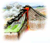
May 7 - Several small nuée ardents flow down the Riviere Blanche valley as a result of small collapse events from the lava dome in the crater. May 8, 7:50 AM - A loud blast is heard from the summit of Mt. Pelée.
May 8, 7:52 AM - All clocks in St. Pierre stop.
A powerful nuée ardent rolls down the valley of the Riviere Blanche.
The densest part of the cloud remains in the valley, but part of the pyroclastic flow overtops the valley walls and engulfs St. Pierre.
All but 2 people out about 29,000 are killed in the next 2 to 3 minutes.
Ships in the harbor catch fire and sink.
Walls up to 1 meter thick are knocked down, roofs are blown off, and many burn, iron bars are bent and twisted, but some areas of the city are affected more than others.
Still, nearly all humans and animals die, even in parts of the city not knocked down by the blast. Many of the victims are badly burned, yet their clothing is not singed.
Most appear to have died from asphyxiation due to breathing the hot mixture of gas and dust.
One survivor was locked in a small prison cell with only a small barred opening on facing the north.
His body was badly burned and he reported that the heat only lasted a few seconds.
This survivor later joined the circus and traveled around the world telling his story of survival and showing his badly burned back.
May 20 - A second nuée ardent sweeps through St. Pierre.
There are no deaths (They all died on May 8!) May 30 - A third nuée ardent takes a somewhat different path, engulfing not only St. Pierre, but also the town of Morne Rouge where it kills an additional 2,000 people.
This eruption is an extremely important event because it was the first time that the scientific community became aware of the phenomena of pyroclastic flows.
Mt. St. Helens, 1980
The video on Mount St. Helens is spectacular.
The following are the major points of the events leading to the eruption, the eruption itself, and following the eruption, shown in the video.
There will likely not be enough time to discuss these points in class.
The last portion of the video discusses the prediction of dome eruptions that have taken place since the May 18 eruption and was discussed in the previous lecture.
In a 1975 volcanic hazards study of Mount St. Helens, U.S. Geological Survey geologists D.R. Crandell,
D. Mullineaux and M. Rubin noted that Mount St. Helens had been built within the last 2,500 years with the last eruption in 1857.
Major eruptions had occurred every hundred years or so and St. Helens was one of the most active volcanoes in the Cascade Range.
In their paper they stated that Mount St. Helens "will erupt again in the next 100 years, perhaps before the end of the century."
Mount St. Helens did reawaken on March 21, 1980 when a magnitude 4.2 earthquake occurred beneath the volcanoe.
Earthquakes continued until March 27 when a phreatic eruption occurred at the summit.
Similar small eruptions took place through mid April and the summit of the mountain developed a new crater due to the explosions.
Note that only pre-existing rock fragments were ejected during these initial eruptions.
By mid-April volcanic tremor had begun beneath the mountain indicating the movement of magma.
By the end of April surveys showed that the north face of the mountain above an older volcanic dome, known as the Goat Rocks Dome, had begun to bulge upwards and outwards at rates up to 1 m per day.
By May 12, the bulge had displaced parts of the northern part of the volcanoe a distance of about 150 m.
Geologists now recognized that this bulge could soon develop into a landslide, but were uncertain when or if it would occur and how big the slide would be.
Most of the area in the danger zone (called the red zone) had been evacuated, but intense pressure from people with cabins and homes within the red zone forced the Governor of Washington to open the area to allow land owners to return under police supervision to retrieve their belongings.
The first of these escorted entries into the red zone took place on May 17, and a second caravan was scheduled for the morning of May 18.
Fortunately the latter expedition was not scheduled to leave until 9:00 A.M.
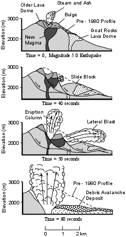
8:32 AM on May 18, 1980 a magnitude 5.0 earthquake occurred beneath Mt. St. Helens.
This led to a violent eruption that took place over about the next minute.
The earthquake triggered a large landslide that began to slide out to the north, initially as three large blocks.
As the first block, containing the old Goat Rocks lava dome, began to slide downward, the magma chamber beneath the volcanoe became exposed to atmospheric pressure.
The gas inside the magma expanded rapidly, producing a lateral blast that moved outward toward the north.
As the second slide block began to move downwards a vertical eruption column began to form above the volcanoe.
The lateral blast rapidly overtook the slide block and roared through an area to the north of the mountain, knocking down all trees in its path and suffocating all living things, including humans.
Within the next 10 seconds the third slide block moved out toward the north.
All slide blocks banked up against the mountain north of Spirit Lake and were then diverted down the North Fork of the Toutle River valley toward the west, breaking up into smaller blocks as they moved down slope.
The landslide thus became a debris avalanche and left a deposit extending about 20 km down the valley (see map).
The southern shores of Spirit Lake were displaced about 1 km northward and the level of the lake was raised about 40 m.
Harry Truman's Lodge was buried by the debris avalanche.
Within about the first minute of the eruption the lateral blast had ceased, the debris avalanche had been deposited, and the summit of Mount St. Helens had been reduced by about 500 m.
The magma however continued to erupt in a Plinian eruption column that reached up to 26 km into the atmosphere.
The eruption column collapsed several times to produce pyroclastic flows that moved into Spirit Lake and the upper reaches of the Toutle River Valley.
This Plinian phase lasted about 9 hours and spread tephra in a plume to the east, darkening the area at midday to make it appear like night.
During this first minute of the eruption everything within the lateral blast zone had been knocked down and covered with a thin layer of ash.
Trees along about a 100 m wide zone surrounding the blast zone had been stripped of their vegetation or severely singed to a brownish color.
In all, 62 people lost their lives, either by being buried by the debris avalanche deposit, or suffocating by breathing the hot gases and dust of the blast.
Some also died in the cars or trucks when pieces of wood were driven through the cars by the blast. Over the next several days melted snow combined with the new ash to produce mudflows that roared down the North and South Forks of the Toutle River and drainages to the south of the volcanoe .
Logs were carried into the Columbia River and so much sediment accumulated in the shipping channel of the Columbia River that it cost several hundred million dollars to dredge the channel and remove the logs so that shipping could continue.
Eastern Washington was covered in volcanic ash for months after the eruption and relief efforts were slow.
Although the tephra fall deposits that accumulated in eastern Washington were anticipated by the prior volcanic hazards study, most planning for rescue and recovery had concentrated on the area immediately around Mount St. Helens.
In general, the eruption had been much larger than most anticipated, but the fact that a hazards study had been carried out, that public officials were quick to act and evacuate the danger zone, and that the volcanoe was under constant monitoring, resulted in the minimization of loss of life to only 62 instead of a much larger number that could have been killed had not these efforts been in place.
Since the 1980 eruption, several volcanic domes have been emplaced in the crater and some have been blasted out.
In the future, it is expected that new domes will continue to form, eventually building the volcanoe back to a form that will look more like it did prior to the 1980 eruption.
Volcanoe Types - some images...
| Cinder | Spatter |
| Composite | Strombolian |
| Hawaiian | Submarine |
| Pelean | Surtseyan |
| Shield | Vulcanian |