Underground Water

Underground Water
based on Donald Bruehl's website http://www.geocities.com/RainForest/4619/index.html used with permission (*note: site is no longer live)
Occurrence of Groundwater
Subsurface Exploration
Groundwater Monitoring
Groundwater Modeling
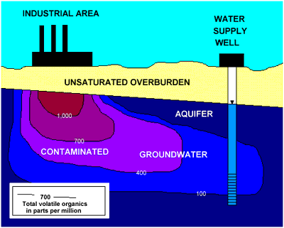
Groundwater Quality
Groundwater Remediation
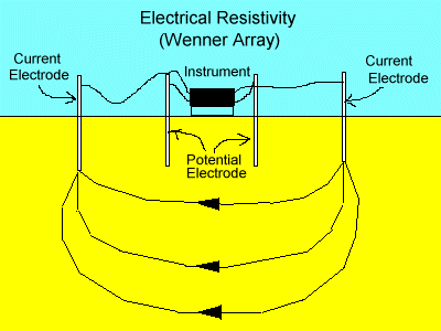
Geophysical Methods of Exploration
Occurrence of Groundwater
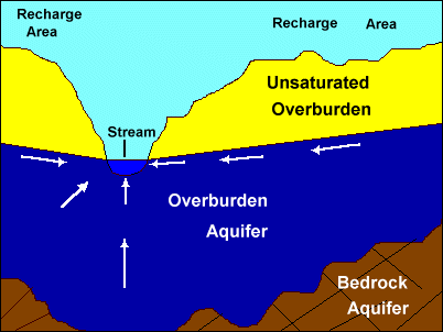
Most groundwater originates from rainfall that has entered the earth. The drawing shows a typical situation with water saturated soils (overburden aquifer) over a bedrock aquifer. In the overburden aquifer, water fills the void space between grains of the soil.
Bedrock aquifers underlie the surface soils (overburden) and overburden aquifers. In the bedrock aquifers, water occurs in fractures and other voids in the bedrock. Some types of bedrock such as sandstone may also have additional voids (intergranular voids) that are filled with groundwater.
As is the case for surface water, groundwater flows from higher elevations (or
pressures) toward lower elevations (or lower pressures). Groundwater flow is
usually toward a groundwater discharge area, as shown in the illustration. The
stream in the drawing represents a typical groundwater discharge area.
Groundwater pressure, rather than elevation, controls the rate and direction of
flow in confined (or artesian) aquifers. Those are aquifers that are isolated under impervious or poorly pervious strata (aquicludes and aquitards).
Subsurface Exploration
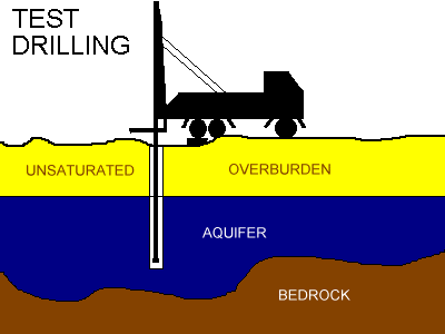
The subterranean realm is underground everywhere and most of us are totally oblivious to its existance. In order to know what exists below the surface of the earth, subsurface exploration of one type or another must be done. The illustration shows one type of subsurface exploration,
Test drilling.
During drilling, samples of the earth may be brought to the surface
for us to observe. After enough test drilling has been completed, the structure of
the subsurface can be reconstructed. The borings can then be converted into
wells by installing pipe with slots or holes, or a screen section to permit water to enter. Then the depth to water can be measured and groundwater samples can be collected for analysis to investigate flow direction, the composition of the water, and if it contains contaminants.; There are other methods that may be used to explore the subterranean realm. They include excavation and mining, cavern entry and exploration, and indirect methods that may involve geophysical techniques.
Groundwater Monitoring

Groundwater monitoring is performed in a number of situations with varying objectives. It involves measuring the physical and/or chemical properties of groundwater on a periodic basis. Concentrations of contaminants are frequently monitored to determine if they are increasing, decreasing, or remaining in the same range. Monitoring is also performed at and in the vicinity of water supply sources to determine the quality of the water and trends of indicators of water quality. Groundwater monitoring programs normally involve an array of monitoring or observation wells or microwells.
The drawing indicates a shallow overburden aquifer monitoring well and some of its basic features. A well of this type makes it possible to measure the groundwater elevation and permits water sampling to test the composition of the groundwater.
Groundwater Modeling Groundwater Flow Modeling
Groundwater flow modeling is generally used to define the quantity of groundwater available or direction of dissolved contaminant migration. It is also used to define the limits of a capture zone for a contamination recovery well (or well field), or for delineating a water well protection area (or recharge area) for a water supply. Groundwater scientists frequently use analytical means to model these situations using the classical mathematical formulas to estimate the effect on the groundwater surface. In order to estimate the long-term yield and water-level drawdown of a recovery or water supply well (or well field) they often use the classical formulas for making projections.
Modeling by manual calculations (analytical modeling) can be very time-consuming and, therefore expensive. Therefore,groundwater scientists have prepared a number of computer groundwater modeling programs that allow for a more rapid and efficient assessment of groundwater flow under conditions that may involve the addition of simulated wells and/or simulated sources of recharge in an existing flow field. The models often generate contour maps that illustrate relevant data that are related to groundwater flow. The computer output is usually plotted as groundwater elevation (or artesian pressure) maps for further analysis.
Solute Transport Modeling
Groundwater Quality
Groundwater quality reflects substances that are dissolved or suspended in the water. Suspended material is not transported far in most subsurface
materials, but it is usually filtered out.
In general, groundwater flow is very slow and depends on the permeability (water transmitting ability) of
the subsurface materials, as wells as the hydraulic gradient (slope of the water-table or pressure gradient for artesian conditions).
The rate of groundwater flow is usually measured in feet (or meters) per day or feet (or meters) per year. In some situations where flow is slow it is measured in inches (or centimeters) per year.
Groundwater usually contains higher concentrations of natural dissolved materials than surface water. The materials dissolved in the water usually reflect the composition and solubility of the earth materials (soil or rock) that the
groundwater is in contact with and time that it has been in the subsurface.
A number of the activities of man pose threats to water quality Some of these activities include:
- Landfill solid waste disposal
- Liquid waste disposal basins
- Septic waste infiltration systems
- Highway deicing with chemicals (eg. salt)
- Gasoline service stations
- Petroleum bulk storage facilities
- Underground storage tanks
- Many industrial activities
- Livestock feed lots
- Urban stormwater infiltration
Groundwater scientists have used a number of different computer models to evaluate the transport of various dissolved organic and inorganic compounds in groundwater in a number of geologic situations.>
One frequently encountered modeling situation involves the assessment of the distribution of hydrocarbon concentrations around a contaminant source to evaluate various remedial scenarios including removal of the source of contamination, concentration reductions resulting from consumption by microbes, effect of groundwater recovery wells, and recharge sources.
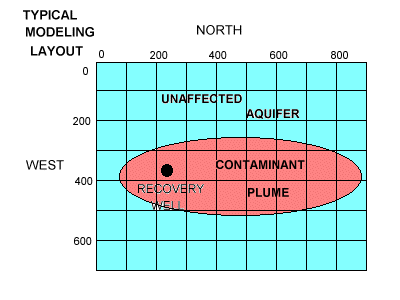
The illustration on the right shows a simple grid layout for solute transport modeling. Such models can be used to predict the time required for aquifer cleanup or for natural concentration reductions by existing processes in the subsurface.
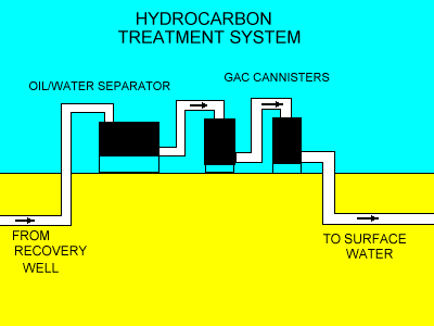
Groundwater Remediation
The illustration shows a schematic drawing for a treatment system
for removing petroleum (gasoline or oil) components from groundwater.
If groundwater contamination is identified on a site, and if contaminant
concentrations are found above regulatory limits, remedial activities or feasibility studies must be done just to keep a site in compliance. Such activities vary with the contaminant, medium that is contaminated, and surrounding environmental factors.
Common remedial methods include the following:
- Excavation and offsite removal.
- Excavation and onsite treatment
- Groundwater "pump and treat"
- Soil vapor extraction Sparging
- Passive recovery of non-aqueousphase liquids(NAPL)
- Enhanced bioremediation
- Onsite encapsulation
- In-situ onsite treatment
Geophysical Methods of Exploration