Mass Movement
Mass Movement
based on JAS West's excellent web page http://members.tripod.com/~Jenn2000/main.html -site closedLandslides
Soil Creep
Debris flow
Mud flows and Lahars
Solifluction
Rock Falls and Rock Slides
Resources
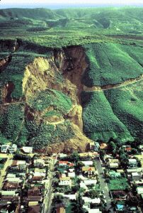
California landslide. Image courtesy of USGS
Landslides
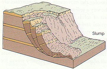
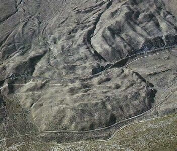
Landslides...a rapid downslope movement of rock or soil as a more or less coherent mass. Landslides are characterized by a slippage plane that is clearly defined. A landslide may turn into a flow at the bottom as the blocks become tumbled over. Usually the material moves as a large block known as a slump block. The scar above a landslide is easily visible. Steep slopes of shale are susceptible to landslide activity. But landslides occur everywhere on large or small scales. They can occur after earthquakes or removal of part of the slope due to construction, particularly in the construction of roads.
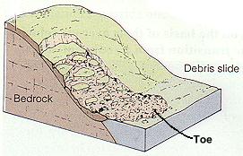
General mechanism of a landslide
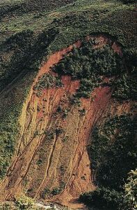
Slump blocks and scar in Guatemala: General Diagram of a slump
Pore Water Pressure is the key to monitoring landslides.
Pore water pressure is the pressure that develops as water fills in the pore spaces inbetween particles. Shear strength, a resisting force, decreases and the weight, a driving force, increases. The safety factor becomes less than one and a movement becomes possible.
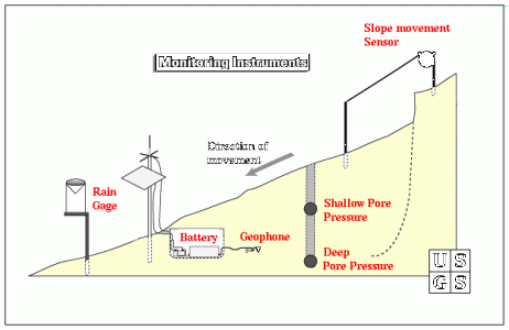
Diagram of the apparratus used to monitor Pore Water Pressure
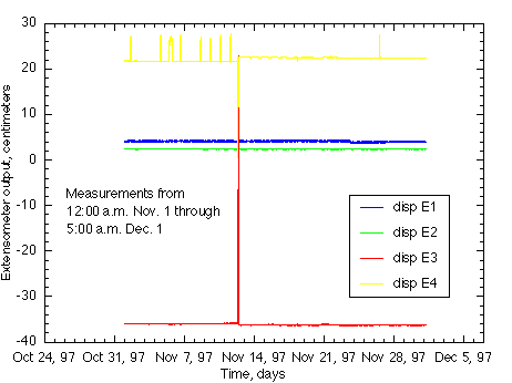
Equipment such as this measures the Deep Pore Pressure and Shallow Pore Pressure. Data received from one of these monitors may look like this:
"Steady change in the extensometer output (vertical axis) indicates downslope movement, brief changes that return to a constant value, such as the spikes in the graph of E-4 (yellow), usually result from physical or electrical disturbances and do not indicate movement."
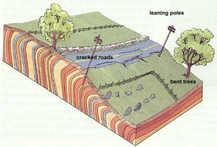
Soil Creep
Soil Creep is a very, very slow form of mass wasting. It's just a slow adjustment of soil and rocks that is so hard to notice unless you can see the effects of the movement. These effects would be things like fenceposts shifted out of alignment, or telephone poles tipping downslope.
Another effect is the way a grass covered slope seems to ooze downhill forming little bulges in the soil. This heaving of the soil occurs in regions subjected to freeze-thaw conditions. The freeze lifts particles of soil and rocks and when there is a thaw, the particles are set back down, but not in the same place as before.
Gravity always causes the rocks and soil to settle just a little farther downslope than where they started from. This is the slow movement that defines creep. Creep can also be seen in areas that experience a constant alternation of wetting and drying periods which work in the same way as the freeze/thaw.
Monitoring is essentially done through observation of the effects of creep. Since the process is so slow, it can only be monitored in terms of flow over long periods of time.
Debris Flows...
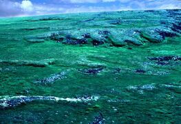
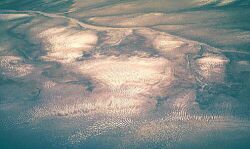
An ancient debris flow showing just how big they can be are one of the most dangerous of all mass wasting events. They can occur suddenly and inundate entire towns in a matter of minutes.
Debris flows are made of exactly what the name suggests: debris. This debris can include anything from the smallest mud particles to boulders, trees, cars, and parts of buildings. Debris flows occur when rain water begins to wash material from a slope or when water sheets off of a freshly burned stretch of land. Chapparral land is especially susceptible to debris flows after a fire. The rapidly moving water cascades down the slopes, and into the canyons and valleys below. It picks up speed and some debris as it descends the valley walls. In the valley itself, months of dry ravel, loose soil and rocks that have rolled or slid off the slope, begins to move with the water.
As the system gradually picks up speed, the flow takes on the characteristics of a basic river system. The faster the water flow, the more the water can pick up. As the water picks up more mud and rocks, it begins to resemble a fast flowing river of concrete. This wall of debris can move so rapidly that it can pluck boulders the size of cars from the floors of the canyons and hurl them along the path of the flow. It's the speed and enormity of carried particles that makes a debris flow so dangerous. Boulders crash through homes and the mud-water mix fills in the rooms sometime totally overtaking the house.
People have tried many methods for stopping or diverting debris flows. In California, catch basins have ben constructed to "catch" the debris. Some basins have special overflow ducts with screens to remove the water from the flow and allow more room for the bigger items that may be washed in and take up needed space.
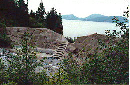
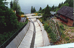
Catch basin in British Columbia, Canada Debris Chute in British Columbia, Canada
Debris flows happen so rapidly that there is really no way to monitor one until it is on top of you. Instruments in catch basins and flow channels can measure the rate or discharge of the flow by calculating the amount (volume) of material per unit of time (usually seconds).
Mud flows and Lahars...
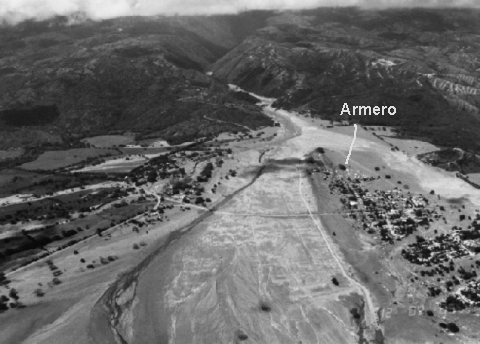
are special forms of debris flows that are mainly made of the smallest mud and silt particles. Extremely heavy rain, or a sudden thaw can trigger these types of flows. In the case of lahars, a sudden thaw of mountain snow due to a volcanic eruption can send a torrent of mud, ash, and hot water down the slope of the volcano and over neighboring towns.As can be seen from this photograph of the unfortunate town of Armero, a lahar can overtake a town far from a volcano. This lahar rushed down stream and river valleys into the town and killed over 23,000 people. They had no warning. The town was quickly buried by mud that later, as rescuers attempted to find victims, dried and hardened like cement.
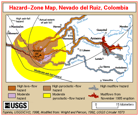
This map shows how the lahar found it's way to Armero and the extent of the flow.
In parts of Canada and Scandinavia, a special type of mudflow can occur. Marine mud at the margins of a receding glacier can have a property known as quick clay. There is a high water content in these marine muds due to their relatively low compaction. These clays can change into a viscous fluid with only the slightest disturbance. They become flows that can move very rapidly even on a slight grade. Since these flows also give no warning, they can be very destructive.
Solifluction
...a major type of mass movement in cold polar regions and some high mountains. Solifluction is a special type of creep that occurs in areas of permafrost. Permafrost refers to the layer of groundwater that fills in the pore spaces of soil and rock that is permanently frozen. The permafrost layer can be anywhere from a meter to several hundred meters thick. It takes up about 20% of the world's land. In times of warm weather, the ground will begin to thaw from the surface downward. All of the freshly melted water cannot absorb into or move through the permafrost layer.
This causes the upper layer of soil and regolith to become saturated and flow down the slightest of slopes as it slips over the frozen ground underneath. Another visible aspect of solifluction areas is cryoturbation
.
During cryoturbation, "small ridges and mounds of bare soil are produced by the processes of frost churning (cryoturbation) and soil flow (solifluction). Freeze-thaw generates a circular motion in the surface material, heaving the soil to the surface (the light- coloured areas) and dragging it down at the margins to form gutters (the darker, vegetated areas). The process creates a network of circular patches which, on slopes, are stretched into long stripes by an additional creeping movement. Flowing water then deepens the gutters." (Terrain Sciences Division)
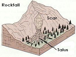
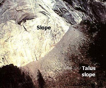
Rock Falls and Rock Slides
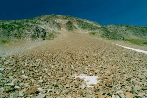
Falls are usually the free-fall of pieces of rock from a mountain or cliff face. The size of the piece(s) can range from tiny grains to blocks weighing a ton or more. The debris and rock fragements from rock falls collect at the base of the slope as talus. This talus protects the base of the mountain from erosion. On mountains, ice wedging is the main contributor.
As water from snowmelt finds its way into the cracks and joints of the rock face, it may refreeze and being to expand. This expansion widens the cracks in the rock. Over time, the cracks have been widened enough so that they are a point of structural weakness. Gravity takes over and the pieces of rock fall from the face of the mountain.
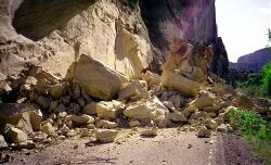
Rock slides can travel a long way from the source of the initial fall
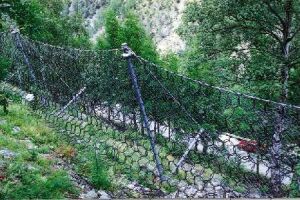
Slides are rapid downslope movements of blocks along a bedding plane, joint, or area of weakness. The blocks tend to break up into smaller pieces as the slide moves downslope and large pieces collide with each other. These pieces can travel a great distance due to the force of the falling rock. Road cuts are susceptible to rock falls and slides when the base of a mountain is removed for the roadbed. So to make the roads safer for motorists, some protective barriers have been designed to catch the falling rocks:
Resources
Terrain Sciences Division Landforms Page
Terrain Sciences Division Geohazards: Landslides and Snow Avalanche Page
USGS Landslide Website
Oregon State University's Geology Dept. Index
USGS Geological Hazard Team Website
California Real-Time Landslide Monitoring Project