Background to Flood Study

Background to Flood Study
Background
-
the Johnstone River System
Objectives of the Flood Study
The Seven Key Stages in the Study
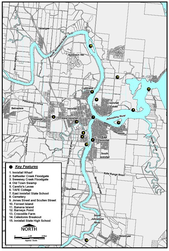
Key Locations in Flooding Study
back to
Case Study- Johnstone River Flood...
Key Locations in Flooding Study
Background
The Johnstone River system comprises the North Johnstone River and the South Johnstone River with their confluence being at the town of Innisfail. From the confluence, the river flows about 5 km to the ocean. The rivers have a combined catchment of about 1600 km2 with the North Johnstone being the larger of the two with a catchment of about 1030 km2.
The headwaters of the rivers are in the high rainfall area of the Cardwell Ranges. The rivers flow from the range down through gorges to the lower fertile floodplains that are predominantly utilised for agricultural purposes including sugarcane and banana farming. There are a number of townships on the floodplains including the major centre of Innisfail and the smaller townships of South Johnstone, Mourilyan, Wangan and Mundoo.
There is a history of severe flooding on the floodplain with considerable damage to property,agriculture and public infrastructure. Innisfail is most affected being at the confluence of the rivers and with development on flood prone land.
Flooding in and around Innisfail town occurs initially through backup of Saltwater and Sweeneys Creeks and then through overtopping of the banks around Innisfail and further to the north in larger floods.
The construction of floodgates on Sweeneys and Saltwater Creeks has helped to reduce the frequency of flooding in Innisfail, although the floodgates are overtopped in larger floods. The suburbs of Webb, East Innisfail and South Innisfail are affected by overtopping of the river banks and by back up from the Johnstone River through the Ninds Creek catchment. Parts of Innisfail Estate are affected in larger floods through overtopping of the river bank. Mourilyan is affected in larger floods when the South Johnstone River overtops its banks. These floodwaters pass through Mourilyan and into the Ninds Creek catchment before rejoining the Johnstone River at the confluence with Ninds Creek.
Consideration of options to reduce flooding impacts, and planning for future development requires an understanding of the flood behaviour. To develop a greater understanding of flooding, hydrological and hydraulic flood models were developed and calibrated to historical floods. These models were then used to simulate a range of design floods that were the benchmark for assessing both past and future works.
Once flood behaviour is understood, a strategic approach to controlling development on flood prone land, assessing the advantages and disadvantages of flood mitigation options, flood proofing properties and buildings, educating and safeguarding communities and protecting the natural environment can be carried out with confidence. This Study provides such assessments, and actions arising from the Study recommendations will be used to formulate a Floodplain Management Plan.
There have been a number of developments on the floodplain over the last 30 years that have raised concerns within the community as to their impact on flood behaviour. These include a levee on the northern bank of the river downstream of Innisfail known in the community as Carello’s levee, filling of the town swamp and construction of floodgates to protect the town. The flood model was used to quantify these impacts.
Objectives
br> The key objectives of the study were as follows: 1. develop a state-of-the-art computer model of the Johnstone Rivers System within the study area to define the nature and extent of the flood hazard;
2. model the effects of existing developments and existing flood mitigation measures to determine their impact on flooding, including community concerns raised during the resident survey and community open sessions;
3. propose, assess and recommend possible flood mitigation measures with consideration given to social, ecological and economic factors;
4. prepare a report detailing the development of the model, the assessment of the effect of existing development and flood mitigation measures, addressing community concerns and detailing proposed flood mitigation measures;
5. prepare a Floodplain Management Plan.
There were seven key stages in the study.
1. Data Collection
2. Flood Model Development and Calibration
3. Design Flood Analysis and Existing Flood Damage Assessment
4. Historical Floodplain Works Assessment
5. Floodplain Management Measures Assessment
6. Recommendation of Management Measures
7. Reporting