Groundwater

Groundwater
back to Contents of Entire Course...
see
also...Underground Water a mirror of Donald Bruehl's website
The Water Table
Movement of Groundwater
Porosity
Permeability
Movement in the Zone of Aeration
Movement in the Saturated
Zone
Recharge Areas and Discharge
Areas
Discharge and Velocity
Springs and Wells
Aquifers
Changes in the Groundwater
System
Water Quality and
Groundwater Contamination
Geologic Activity of
Groundwater
Pollution from factories and
underground storage tanks
Liquid that leaks is less
dense than water
Liquid that is not very soluble in water
Liquids that are denser than water
Cemeteries are another source of
pollution
Contamination by sea water
adapted to HTML from lecture notes of Prof. Stephen A. Nelson Tulane University
Groundwater is water that exists in the pore spaces and fractures in rock and sediment beneath the Earth's surface. It originates as rainfall or snow, and then moves through the soil into the groundwater system, where it eventually makes its way back to surface streams, lakes, or oceans.
- Groundwater makes up about 1% of the water on Earth (most water is in oceans).
- But, groundwater makes up about 35 times the amount of water in lakes and streams.
- Groundwater occurs everywhere beneath the Earth's surface, but is usually restricted to depths less that about 750 meters.
- The volume of groundwater is a equivalent to a 55 meter thick layer spread out over the entire surface of the Earth.
- The surface below which all rocks are saturated with groundwater is the water table.
The Water Table
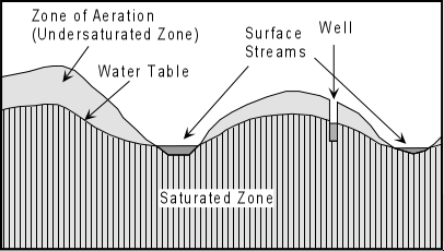
Rain that falls on the surface seeps down through the soil and into a zone called the zone of aeration or unsaturated zone where most of the pore spaces are filled with air. As it penetrates deeper it eventually enters a zone where all pore spaces and fractures are filled with water. This zone is called the saturated zone. The surface below which all openings in the rock are filled with water (the top of the saturated zone) is called the water table
The water table occurs everywhere beneath the Earth's surface. In desert regions it is always present, but rarely intersects the surface.
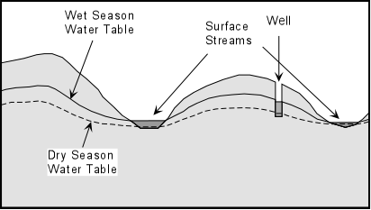
In more humid regions it reaches the surface at streams and lakes, and generally tends to follow surface topography. The depth to the water table may change, however, as the amount of water flowing into and out of the saturated zone changes. During dry seasons, the depth to the water table increases. During wet seasons, the depth to the water table decreases.
Movement of Groundwater
Groundwater is in constant motion, although the rate at which it moves is generally slower than it would move in a stream because it must pass through the intricate passageways between free space in the rock. First the groundwater moves downward due to the pull of gravity. But it can also move upward because it will flow from higher pressure areas to lower pressure areas, as can be seen by a simple experiment illustrated below. Imagine that we have a "U"-shaped tube, filled with water. If we put pressure on one side of the tube, the water level on the other side rises, thus the water moves from high pressure zones to low pressure zones.
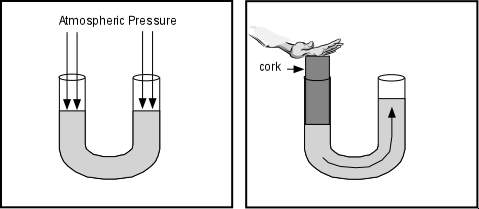

The same thing happens beneath the surface of the Earth, where pressure is higher beneath the hills and lower beneath the valleys
The rate of groundwater flow is controlled by two properties of the rock: porosity and permeability.
Porosity
is the percentage of the volume of the rock that is open space (pore space). This determines the amount of water that a rock can contain.
In sediments or sedimentary rocks the porosity depends on grain size, the shapes of the grains, and the degree of sorting, and the degree of cementation.
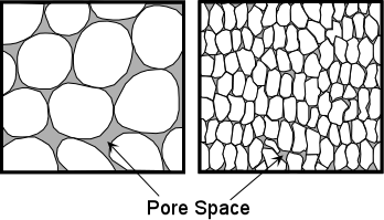
Well-rounded coarse-grained sediments usually have higher porosity than fine-grained sediments, because the grains do not fit together well.
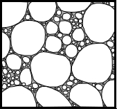
Poorly sorted sediments usually have lower porosity because the fine-grained fragments tend to fill in the open space.
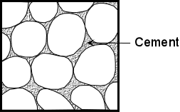
Since cements tend to fill in the pore space, highly cemented sedimentary rocks have lower porosity.
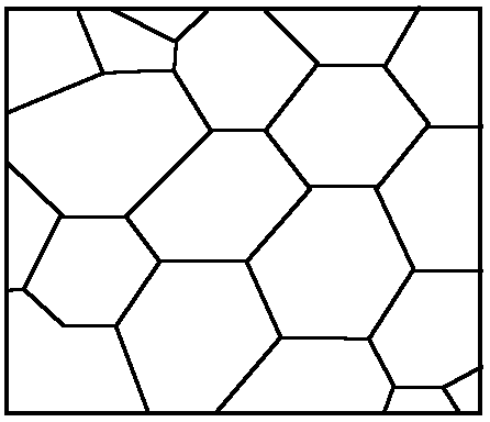
In igneous and metamorphic rocks porosity is usually low because the minerals tend to be intergrown, leaving little free space. Highly fractured igneous and metamorphic rocks, however, could have high porosity
Permeability
is a measure of the degree to which the pore spaces are interconnected, and the size of the interconnections. Low porosity usually results in low permeability, but high porosity does not necessarily imply high permeability. It is possible to have a highly porous rock with little or no interconnections between pores. A good example of a rock with high porosity and low permeability is a vesicular volcanic rock, where the bubbles that once contained gas give the rock a high porosity, but since these holes are not connected to one another the rock has low permeability.
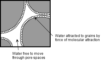
A thin layer of water will always be attracted to mineral grains due to the unsatisfied ionic charge on the surface. This is called the force of molecular attraction. If the size of interconnections is not as large as the zone of molecular attraction, the water can't move. Thus, coarse-grained rocks are usually more permeable than fine-grained rocks, and sands are more permeable than clays.
Movement in the Zone of Aeration
Rainwater soaks into the soil where some of it is evaporated, some of it adheres to grains in the soil by molecular attraction, some is absorbed by plant roots, and some seeps down into the saturated zone. During long periods without rain the zone of aeration may remain dry.
Movement in the Saturated Zone
In the saturated zone (below the water table) water percolates through the
interconnected pore spaces, moving downward by the force of gravity, and
upward toward zones of lower pressure. Where the water table intersects
the surface, such as at a surface stream, lake, or swamp, the groundwater
returns to the surface.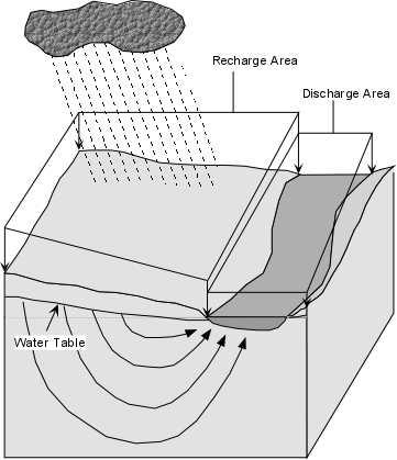
Recharge Areas and Discharge Areas
The Earth's surface can be divided into areas where some of the water falling on the surface seeps into the saturated zone and other areas where water flows out of the saturated zone onto the surface. Areas where water enters the saturated zone are called recharge areas, because the saturated zone is recharged with groundwater beneath these areas. Areas where groundwater reaches the surface (lakes, streams, swamps, & springs) are called discharge areas, because the water is discharged from the saturated zone. Generally, recharge areas are greater than discharge areas.
Discharge and Velocity
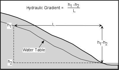
The rate at which groundwater moves through the saturated zone depends on the permeability of the rock and the hydraulic gradient. The hydraulic gradient is defined as the difference in elevation divided by the distance between two points on the water table. Velocity, V, is then:
V = K(h2 - h1)/L
where K is the coefficient of permeability.If we multiply this expression by the area, A, through which the water is moving, then we get the discharge, Q.
Q = AK(h2 - h1)/L, which is Darcy's Law.
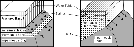
Springs and Wells
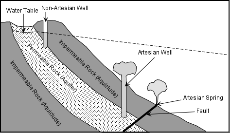
A spring is an area on the surface of the Earth where the water table intersects the surface and water flows out of the ground. Springs occur when an impermeable rock (called an aquiclude) intersects an permeable rock that contains groundwater (an aquifer). Such juxtaposition between permeable and impermeable rock can occur along geological contacts (surfaces separating two bodies of rock), and fault zones.
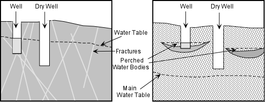
A well is human-made hole that is dug or drilled deep enough to intersect the water table. Wells are usually used as a source for groundwater. If the well is dug beneath the water table, water will fill the open space to the level of the water table, and can be drawn out by a bucket or by pumping. Fracture systems and perched water bodies can often make it difficult to locate the best site for a well.
Aquifers
An aquifer is a large body of permeable material where groundwater is present in the saturated zone. Good aquifers are those with high permeability such as poorly cemented sands, gravels, and sandstones or highly fractured rock. Large aquifers can be excellent sources of water for human usage such as the High Plains Aquifer (in sands and gravels) or the Floridian Aquifer (in porous limestones) as outlined in your text.
Aquifers can be of two types:
- Unconfined Aquifers - the most common type of aquifer, where the water table is exposed to the Earth's atmosphere through the zone of aeration. Most of the aquifers depicted in the drawings so far have been unconfined aquifers.
- Confined Aquifers - these are less common, but occur when an aquifer is confined between layers of impermeable strata. A special kind of confined aquifer is an artesian system, shown below. Artesian systems are desirable because they result in free flowing artesian springs and artesian wells.
Changes in the Groundwater System
When discharge of groundwater exceeds recharge of the system, several adverse effects can occur. Most common is lowering of the water table, resulting in springs drying up and wells having to be dug to deeper levels. If water is pumped out of an aquifer, pore pressure can be reduced in the aquifer that could result in compaction of the now dry aquifer and result in land subsidence. In some cases withdrawal of groundwater exceeds recharge by natural processes, and thus groundwater should be considered a non-renewable natural resource.
Water Quality and Groundwater Contamination
Water quality refers to such things as the temperature of the water, the amount of dissolved solids, and lack of toxic and biological pollutants. Water that contains a high amount of dissolved material through the action of chemical weathering can have a bitter taste, and is commonly referred to as hard water. Hot water can occur if water comes from a deep source or encounters a cooling magma body on its traverse through the groundwater system. Such hot water may desirable for bath houses or geothermal energy, but is not usually desirable for human consumption or agricultural purposes. Most pollution of groundwater is the result of biological activity, much of it human. Among the sources of contamination are:
- Sewers and septic tanks
- Waste dumps (both industrial and residential)
- Gasoline Tanks (like occur beneath all service stations)
- Biological waste products - Biological contaminants can be removed from the groundwater by natural processes if the aquifer has interconnections between pores that are smaller than the microbes. For example a sandy aquifer may act as a filter for biological contaminants.
- Agricultural pollutants such as fertilizers and pesticides.
- Salt water contamination - results from excessive discharge of fresh groundwater in coastal areas.
Geologic Activity of Groundwater
- Dissolution - Recall that water is the main agent of chemical weathering. Groundwater is an active weathering agent and can leach ions from rock, and, in the case of carbonate rocks like limestone, can completely dissolve the rock.
- Chemical Cementation and Replacement - Water is also the main agent acting during diagenesis. It carries in dissolved ions which can precipitate to form chemical cements that hold sedimentary rocks together. Groundwater can also replace other molecules in matter on a molecule by molecule basis, often preserving the original structure such as in fossilization or petrified wood
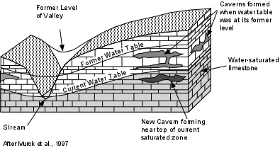
Caves and Caverns
- If large areas of limestone underground are dissolved by the action of groundwater these cavities can become caves or caverns (caves with many interconnected chambers) once the water table is lowered. Once a cave forms, it is open to the atmosphere and water percolating in can precipitate new material such as the common cave decorations like stalagtites (hang from the ceiling), stalagmites (grow from the floor upward), and dripstones, and flowstones.
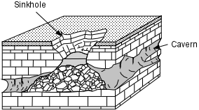
Sinkholes - If the roof of a cave or cavern collapses, this results in a sinkhole. Sinkholes, likes caves, are common in areas underlain by limestones. For example, in Florida, which is underlain by limestones, a new sinkhole forms about once each year, gobbling up cars and houses in process.
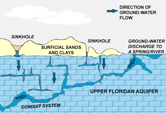
Karst Topography - In an area where the main type of weathering is dissolution (like in limestone terrains), the formation of caves and sinkholes, and their collapse and coalescence may result in a highly irregular topography called karst topography
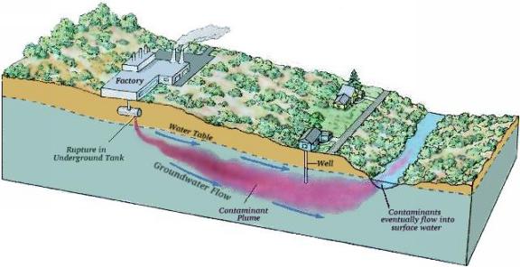
Factories and underground storage tanks
are a source of groundwater pollutants. If a tank with a water soluble liquid leaks the liquid travels down to the water table. It then dissolves in the groundwater. These pollutants flow as a plume along with the groundwater. They can pollute wells and surface water fed by the groundwater along the plume path.
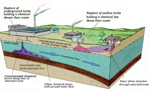
- If the liquid that leaks is less dense than water, it floats on top of the groundwater table. Some of the liquid will evaporate, traveling upwards to the surface in the form of vapor fumes. Some of the liquid will dissolve and travel as a plume in the groundwater.
- If the chemical is not very soluble in water the major part of the liquid will float on the groundwater and flow along with the groundwater.
- Liquids that are denser than water sink through the groundwater until they reach an aquitard. They then move along the top of the aquitard along with the groundwater.
Cemeteries
are another source of pollution for groundwater. They are often located at the top of hills, and are thus upgradient from the local groundwater flow. Decomposing bodies within the cemetery release bacteria, breakdown products from decay and chemicals used for embalming into the local groundwater supply.
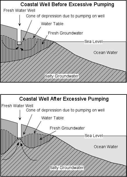
Areas surrounded by the saltwater
, need to be concerned about contamination by sea water. Since the specific gravity of fresh water is less than that of salt water (1.0 vs. 1.025), fresh water floats on top of sea water, forming a fresh water lens.

For every foot of fresh water above the sea level, there are 40 feet of freshwater below sea level. Below the fresh water salt water saturates the aquifer. When you pump out fresh water rapidly, you lower the height of the freshwater in the aquifer forming a cone of depression. The salt water rises 40 feet for ever 1 foot of freshwater depression and forms a cone of ascension. Seawater may eventually enter a well that was once pumping fresh water, making it unusable.

Contour Exercise
Where is the Groundwater divide?
