Queensland's Giant Meteorite Crater?

Queensland's Giant Meteorite Crater?
Queensland's Giant Meteorite Crater? with dimensions of 8.8km by 7.2 km
Information received by Earth Science Australia in 1998 indicates that this feature, while very interesting geologically... It is, we are told, a layered ultramafic intrusion.
- we hope to post details in the near future and would like to get in contact with the graduate student from the Queensland University of Technology who looked at it in December 1998 ----- still waiting at time of writing in 2017
The Questions for which we never received answers:
1.ultramafic rocks originate deep in the earth - the sapphires found in the vicinity of this intrusion are suggestive of a rapid journey from depth to surface -- What was the mechanism that facilitated the intrusion and are the sapphires related to the intrusion?
2. What is the significance of the two N-S major faults and the ENE complimentary fault intersecting adjacent to the intrusion?
3. Has anyone explored for shattercones or melt in the ring structure?
looking at the convincing information provided below....
from the files of the Smithsonian

A circular feature, indicated by the yellow circle, was found at 151 25' 20" East; 24 52' 00" South.
It is about 9 kilometers across.
Gray areas on the map are over 200m.
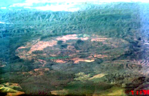
This oblique view of the circular structure taken from a commercial airliner at 24,000 feet on July 11, 1996.
Based on the times of takeoff, landing, and the time of the photograph, it was estimated that the feature was somewhere S or SW of Gladstone.
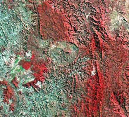
Landsat MSS image obtained July 6 1984.
This false-color image includes near-IR and visible wavelengths; bands 3,2 and 1 are in red, green and blue.
This location was revised when the feature was later identified in a satellite image.
The oblique aerial photograph was taken from the lower left, with agricultural fields on the foreground and the forested hills of the Burnett Range in the background.
Georeferencing of the Landsat image indicates the feature is centered on latiture 24 52' S, longitude 151 25' 20" E.