Plate Tectonics

Plate Tectonics
back to Contents of Entire Course...
Tectonic Theories
The Earth's
Magnetic Field and Paleomagnetism
Sea-Floor Spreading
Plate Tectonics
Types of Plate Boundaries
Divergent Plate Boundaries
Convergent Plate Boundaries
adapted to HTML from lecture notes of Prof. Stephen A. Nelson Tulane University
Plate Tectonics is a theory developed in the late 1960s, to explain how the outer layers of the Earth move and deform. The theory has caused a revolution in the way we think about the Earth. Since the development of the plate tectonics theory, geologists have had to reexamine almost every aspect of Geology. Plate tectonics has proven to be so useful that it can predict geologic events and explain almost all aspects of what we see on the Earth. Although we have discussed plate tectonics throughout the course, in this chapter and lecture we look at how the theory came to be discovered and some of the implications for the evolution of the Earth.
Tectonic Theories
Tectonic theories attempt to explain why mountains, earthquakes, and volcanoes occur where they do, the ages of deformational events, and the ages and shapes of continents and ocean basins.Late 19th Century theories
- Contraction of the Earth due to cooling. This is analogous to what happens to the skin of an apple as the interior shrinks as it dehydrates. This could explain compressional features, like fold/thrust mountain belts, but could not explain extensional features, such as rift valleys and ocean basins. Nor could it explain the shapes and positions of the continents.
- Expansion of the Earth due to heating. This was suggested after radioactivity was discovered. This could explain why the continents are broken up, and could easily explain extensional features, but did not do very well at explaining compressional features.
- Wegner's Theory of Continental Drift
Alfred Wegner was a German Meteorologist who studied ancient climates in the early 1900s. Like most people the jigsaw puzzle appearance of the Atlantic continental margins, caught his attention. He put together the evidence of ancient glaciations and the distribution of fossil to formulate a theory wherein the continents moved over the surface of the Earth, sometimes forming large supercontinents and other times forming separate continental masses. He proposed that prior to about 200 million years ago all of the continents formed one large land mass that he called Pangea .
The weakness of Wegner's theory, and the reason it was not readily accepted by geologists was that he proposed that the continents slide over ocean floor. Geophysicists disagreed, stating the ocean floor did not have enough strength to hold the continents and too much frictional resistance would be encountered.
In 1950s and 1960s, studies of the Earth's magnetic field and how it varied through time (paleomagnetism) provided new evidence that would prove that the continents do indeed drift. In order to understand these developments, we must first discuss the Earth's magnetic field and the study of Paleomagnetism.
The Earth's Magnetic Field and Paleomagnetism
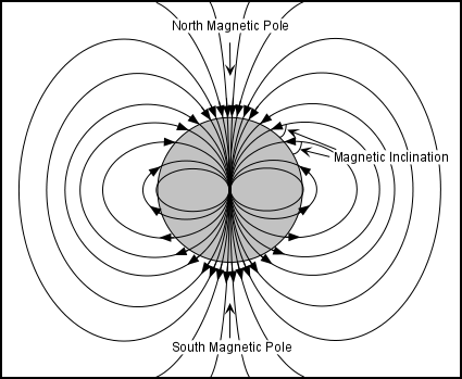
The Earth has a magnetic field that causes a compass needle to always point toward the North magnetic pole, currently located near the rotation pole. The Earth's magnetic field is what would be expected if there were a large bar magnet located at the center of the Earth (we now know that this is not what causes the magnetic field, but the analogy is still good). The magnetic field is composed of lines of force as shown in the diagram here. A compass needle or a magnetic weight suspended from a string, points along these lines of force. Note that the lines of force intersect the surface of the Earth at various angles that depend on position on the Earth's surface. This angle is called the magnetic inclination. The inclination is 0o at the magnetic equator and 90o at the magnetic poles. Thus, by measuring the inclination and the angle to the magnetic pole, one can tell position on the Earth relative to the magnetic poles.
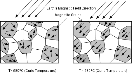
In the 1950s it was discovered that when magnetic minerals cool below a temperature called the Curie Temperature domains within the magnetic mineral take on an orientation parallel to any external magnetic field present at the time they cool below this temperature.At temperatures above the Curie Temperature, permanent magnetization of materials is not possible. Since the magnetic minerals take on the orientation of the magnetic field present during cooling, we can determine the orientation of the magnetic field present at the time the rock containing the mineral cooled below the Curie Temperature, and thus, be able to determine the position of the magnetic pole at that time. This made possible the study of Paleomagnetism (the history of the Earth's magnetic field). Magnetite is the most common magnetic mineral in the Earth's crust and has a Curie Temperature of 580oC
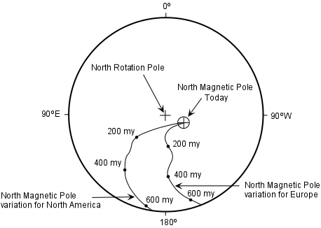
Initial studies of the how the position of the Earth's magnetic pole varied with time were conducted in Europe. These studies showed that the magnetic pole had apparently moved through time. When similar measurements were made on rocks of various ages in North America, however, a different path of the magnetic pole was found.This either suggested that (1) the Earth has had more than one magnetic pole at various times in the past (not likely), or (2) that the different continents have moved relative to each other over time. Studies of ancient pole positions for other continents confirmed the latter hypothesis, and seemed to confirm the theory of Continental Drift.
Sea-Floor Spreading
During World War II, geologists employed by the military carried out studies of the sea floor, a part of the Earth that had received little scientific study. The purpose of these studies was to understand the topography of the sea floor to find hiding places for both Allied and enemy submarines. The topographic studies involved measuring the depth to the sea floor. These studies revealed the presence of two important topographic features of the ocean floor:
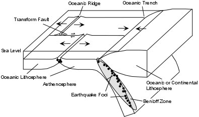
- Oceanic Ridges - long sinuous ridges that occupy the middle of the Atlantic Ocean and the eastern part of the Pacific Ocean.
- Oceanic Trenches - deep trenches along the margins of continents, particularly surrounding the Pacific Ocean.
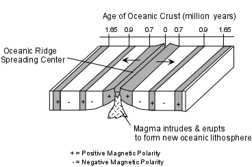
Another type of study involved towing a magnetometer (for measuring magnetic materials) behind ships to detect submarines. The records from the magnetometers, however, revealed that there were magnetic anomalies on the sea floor, with magnetic high areas running along the oceanic ridges, and parallel bands of alternating high and low magnetism on either side of the oceanic ridges. Before these features can be understood, we need to first discuss another development in the field of Paleomagnetism - the discovery of reversals of the Earth's magnetic field and the magnetic time scale.
Reversals of the Earth's Magnetic Field.
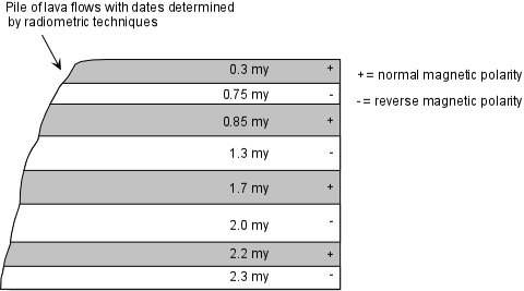
Studying piles of lava flows on the continents geophysicists found that over short time scales the Earth's magnetic field undergoes polarity reversals (The north magnetic pole becomes the south magnetic pole) By dating the rocks by radiometric techniques and correlating the reversals throughout the world they were able to establish the magnetic time scale
Vine, Matthews, and Morely put this information together with the bands of magnetic stripes on the sea floor and postulated that the bands represents oppositely polarized rocks on either side of the oceanic ridges, and that new oceanic crust and lithosphere was created at the oceanic ridge by eruption and intrusion of magma. As this magma cooled it took on the magnetism of the magnetic field at the time. When the polarity of the field changed new crust and lithosphere created at the ridge would take on the different polarity. This hypothesis led to the theory of sea floor spreading.
If new oceanic crust and lithosphere is continually being created at the oceanic ridges, the oceans should be expanding indefinitely, unless there were a mechanism to destroy the oceanic lithosphere. Benioff zones and the oceanic trenches provided the answer: Oceanic lithosphere returns to the mantle by sliding downward at the oceanic trenches (subducting). Because oceanic lithosphere is cold and brittle, it fractures as it descends back into the mantle. As it fractures it produces earthquakes that get progressively deeper.
Plate Tectonics
By combining the sea floor spreading theory with continental drift and earthquake information the new theory of Plate Tectonics became a coherent theory to explain crustal movements.
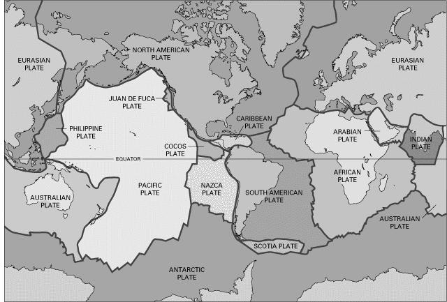
Plates are composed of lithosphere, about 100 km thick, that "float" on the ductile asthenosphere. While the continents do indeed appear to drift, they do so only because they are part of larger plates that float and move horizontally on the upper mantle asthenosphere. The plates behave as rigid bodies with some ability to flex, but deformation occurs only where along the boundaries between plates.
Types of Plate Boundaries
Divergent Plate Boundaries
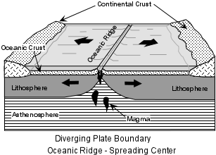
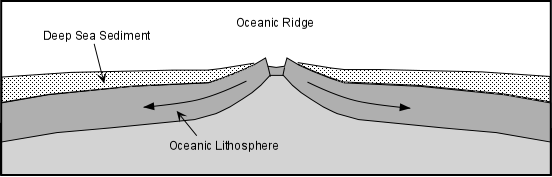
These are oceanic ridges where new oceanic lithosphere is created by upwelling mantle that melts, resulting in basaltic magmas which intrude and erupt at the oceanic ridge to create new oceanic lithosphere and crust. As new oceanic crust is created it is pushed aside in two directions. Thus, the age of the oceanic crust becomes progressively greater in both directions away from the ridge. Because oceanic lithosphere may get subducted, the age of the ocean basins is relatively young. The oldest oceanic crust occurs farthest away from a ridge. In the Atlantic Ocean, the oldest oceanic crust occurs next to the North American and African continents and is about 180 million years old (Jurassic) . In the Pacific Ocean, the oldest crust is also Jurassic in age, and occurs near the coast of Japan.
Because the oceanic ridges are areas of young crust, there is very little sediment accumulation on the ridges. Sediment thickness increases in both directions away of the ridge, and is thickest where the oceanic crust is the oldest.
Knowing the age of the crust and the distance from the ridge, the relative velocity of the plates can be determined. (Absolute velocity requires further information to be discussed later).
- Relative plate velocities vary both for individual plates and for different plates.
- Variations in individual plate velocities occur because spreading of the sea floor takes place on a spherical surface rather than on a flat surface. Velocities are greatest at large distances away from the spreading pole
- Different plates have different velocities depending on the amount of continental lithosphere within the plate. Plates with continental lithosphere have lower relative velocities than plates with only oceanic lithosphere.
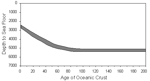
- Sea floor topography is controlled by the age of the oceanic lithosphere and the rate of spreading.
As oceanic lithosphere moves away from the ridge, it cools and sinks deeper into the asthenosphere. Thus, the depth to the sea floor increases with increasing age away from the ridge.
Convergent Plate Boundaries
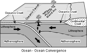
When a plate of dense oceanic lithosphere moving in one direction collides with a plate moving in the opposite direction, one of the plates subducts beneath the other. Where this occurs an oceanic trench forms on the sea floor and the sinking plate becomes a subduction zone. The Benioff zone identifies subduction zones. The earthquakes may extend down to depths of 700 km before the subducting plate heats up and loses its ability to deform in a brittle fashion.
As the oceanic plate subducts, it begins to heat up and metamorphose. As it does so, dehydration reactions release water into the overlying mantle asthenosphere, causing a reduction in the melting temperature and the production of andesitic magmas. These magmas rise to the surface and create a magmatic arc parallel to the trench.
If the subduction occurs beneath oceanic lithosphere, an island arc is produced at the surface (such as the Japanese islands, the Aleutian Islands, the Philippine islands, or the Caribbean islands