Glaciers
Glaciers
back to Contents of Entire Course....
Definition of a glacier
Mountain Glaciers
Ice Sheets: (Continental glaciers)
Ice Shelves
The Formation of Glacial Ice
Changes in Glacier Size
Movement of Glaciers
Glaciation
Glacial Deposits
Glacial Ages
Causes of Glacial Ages
adapted to HTML from lecture notes of Prof. Stephen A. Nelson Tulane
University Glaciers constitute much of the Earth that makes up the cryosphere, the part of the Earth that remains below the freezing point of water. Most glacial ice today is found in the polar regions, above the Arctic and Antarctic Circles. While glaciers are of relatively minor importance today, evidence exists that the Earth's climate has undergone fluctuations in the past, and that the amount of the Earth's surface covered by glaciers has been much larger in the past than in the present. In fact, much of the topography in the northern part of North America, as well as in the high mountain regions of the west, owe their form to erosional and depositional processes of glaciers. The latest glaciation ended only 10,000 years ago.
Definition of a glacier
A glacier is a permanent (on a human time scale, because nothing on the Earth is really permanent) body of ice, consisting largely of recrystallized snow, that shows evidence of downslope or outward movement due to the pull of gravity.
Types of Glaciers
Mountain Glaciers
- - Relatively small glaciers which occur at higher elevations in mountainous regions.
- Smallest of these occupy hollows or bowl-shaped depressions on sides of mountains (cirque glaciers).
- As cirque glaciers grow larger they may spread into valleys and flow down the valleys as valley glaciers. Paths these valley glaciers take are controlled by existing topography.
- If a valley glacier extends down to sea level, it may carve a narrow valley into the coastline. These are called fjord glaciers, and the narrow valleys they carve and later become filled with seawater after the ice has melted are fjords.
- If a valley glacier extends down a valley and then covers a gentle slope beyond the mountain range, it is called a piedmont glacier.
- If all of the valleys in a mountain range become filled with glaciers, and the glaciers cover then entire mountain range, they are called ice caps
Ice Sheets: (Continental glaciers):
are the largest types of glaciers on Earth. They cover large areas of the land surface, including mountain areas. Modern ice sheets cover Greenland and Antarctica. These two ice sheets comprise about 95% of all glacial ice currently on Earth. They have an estimated volume of about 24 million km3. If melted, they contain enough water to raise sea level about 66m (216 ft.). This would cause serious problems for coastal cities (L.A., NY, Washington DC, New Orleans, Miami, SF etc). The Greenland ice sheet is in some places over 3000 m (9800 ft) thick and the weight of ice has depressed much of the crust of Greenland below sea level. Antarctica is covered by two large ice sheets that meet in the central part along the Transantarctic Mountains. These are the only truly polar ice sheet on earth (North Pole lies in an ocean covered by thin layer of ice.
Ice Shelves: Ice shelves
are sheets of ice floating on water and attached to land. They usually occupy coastal embayments, may extend hundreds of km from land and reach thicknesses of 1000 m.
Glaciers can also be classified by their internal temperature.
- Temperate glaciers - Ice in a temperate glacier is at a temperature near its melting point.
- Polar glaciers - Ice in a polar glacier always maintains a temperature well below its melting point
The Formation of Glacial Ice
Glaciers can only form at latitudes or elevations above the snowline, which is the elevation above which snow can form and remain present year round. The snowline, at present, lies at sea level in polar latitudes and rises up to 6000 m in tropical areas. Glaciers form in these areas if the snow becomes compacted, forcing out the air between the snowflakes. As compaction occurs, the weight of the overlying snow causes the snow to recrystallize and increase its grain-size, until it increases its density and becomes a solid block of ice.
Changes in Glacier Size
A glacier can change its size by Accumulation, which occurs by addition of snowfall, compaction and recrystallization, and Ablation, the loss of mass resulting from melting, usually at lower altitude, where temperatures may rise above freezing point in summer. Thus, depending on the balance between accumulation and ablation during a full season, the glacier can grow or shrink
Movement of Glaciers
Glaciers move to lower elevations under the force of gravity by two different processes:
Internal Flow -
called creep, results from deformation of the ice crystal structure - the crystals slide over each other like deck of cards. This type of movement is the only type that occurs in polar glaciers, but it also occurs in temperate glaciers. The upper portions of glaciers are brittle, when the lower portion deforms by internal flow, the upper portions may fracture to form large cracks called crevasses. Crevasses occur where the lower portion of a glacier flows over sudden change in topography
Basal sliding -
meltwater at base of glacier reduces friction by lubricating the surface and allowing the glacier to slide across its bed. Polar glaciers are usually frozen to their bed and are thus too cold for this mechanism to occur.
The velocity of glacial ice changes throughout the glacier. The velocity is low next to the base of the glacier and where it is contact with valley walls. The velocity increases toward the center and upper parts of the glacier.
Glaciation
Glaciation:
is the modification of the land surface by the action of glaciers. Galciations have occurred so recently in N. America and Europe, that weathering, mass wasting, and stream erosion have not had time to alter the landscape. Thus, evidence of glacial erosion and deposition are still present. Since glaciers move, they can pick up and transport rocks and thus erode. Since they transport material and can melt, they can also deposit material. Glaciated landscapes are the result of both glacial erosion and glacial deposition.
Glacial Erosion
- Small scale erosional features
- Glacial striations - long parallel scratches and grooves that are produced at the bottom of temperate glaciers by rocks embedded in the ice scraping against the rock underlying the glacier (see figure 11.18 in your text).
- Glacial polish - rock that has a smooth surface produced as a result of fined grained material embedded in the glacier acting like sandpaper on the underlying surface.
Landforms produced by mountain glaciers
- Cirques - bowl shaped depressions that occur at the heads of mountain glaciers that result form a combination of frost wedging, glacial plucking, and abrasion. Sometimes small lakes, called tarns occur in the bottom of cirque
- Glacial Valleys - Valleys that once contained glacial ice become eroded into a "U" shape in cross section. Stream erosion, on the other hand, produces valleys that are "V" shaped in cross section
- Hanging Valleys - When a glacier occupying a smaller tributary valley meets the larger valley, the tributary glacier usually does not have the ability to erode its base to the floor of the main valley. Thus, when the glacial ice melts the floor of the tributary valley hangs above the floor of the main valley and is called a hanging valley. Waterfalls generally occur where the hanging valley meets the main valley
- Fjords - Fjords are narrow inlets along the seacoast that were once occupied by a valley glacier, called a fjord glacier.
Landforms produced by Ice Caps and Ice Sheets
- Abrasional features - The same small-scale abrasional features such as striations and glacial polish can occur beneath ice caps and ice sheets, particularly in temperate environments.
- Streamlined forms - The land surface beneath a moving continental ice sheet can be molded into smooth elongated forms called drumlins
Glacial Deposits
Since glaciers are solid they can transport all sizes of sediment, from huge house-sized boulders to fine-grained clay sized material. The glacier can carry this material on its surface or embedded within it. Thus, sediment transportation in a glacier is very much different than that in a stream. Thus, sediments deposited directly from melting of a glacial can range from very poorly sorted to better sorted, depending on how much water transport takes place after the ice melts. All sediment deposited as a result of glacial erosion is called Glacial Drift.
Ice Laid Deposits
- Till - nonsorted glacial drift deposited directly from ice. Till consists of a random mixture of different sized fragments of angular rocks in a matrix of fine grained, sand- to clay-sized fragments that were produced by abrasion within the glacier. This fine-grained material is often called rock flour because it is really ground up rock. A till that has undergone diagenesis and has turned into a rock is called a tillite.
- Erratics - a glacially deposited rock or fragment that now rests on a surface made of different rock. Erratics are often found many kilometers from their source, and by mapping the distribution pattern of erratics geologists can often determine the flow directions of the ice that carried them to their present locations.
- Moraines - are deposits of till that have a form different from the underlying bedrock. Depending on where it formed in relation to the glacier moraines can be:
- Ground Moraines - these are deposited beneath the glacier and result in a hummocky topography with lots of enclosed small basins.
- End Moraines and Terminal Moraines are deposited at the low elevation end of a glacier as the ice retreats due to ablation (melting)
- Lateral Moraines are deposits of till that were deposited along the sides of mountain glaciers.
- Medial Moraines - When two valley glaciers meet to form a larger glacier, the rock debris along the sides of both glaciers merge to form a medial moraine. These black streaks in an active glacier, as well as the deposits left behind after the ice melts are called medial moraines.
- Glacial Marine drift - Glaciers that reach the oceans or even lakes, may calve off into large icebergs which then float on the water surface until they melt. Upon melting, the rock debris that they contain becomes immediately deposited on the sea floor or lakebed as an unsorted chaotic deposit. Sometimes single large rock fragments fall out on the floor of the water body, and these are called dropstones.
- Stratified Drift - Glacial drift can be picked up and moved by meltwater streams which can then deposit that material as stratified drift.
- Outwash Plains - Streams running off the end of a melting glacier
are usually choked with sediment and form braided streams, which
deposit poorly sorted stratified sediment in an outwash plain. These
deposits are often referred to as outwash.
- Outwash Terraces - If the outwash streams cut down into their outwash deposits, the banks from river terraces called outwash terraces.
- Kettle Lakes - If depressions form underneath a glacier and remain after the glacier is melted then water filling these depressions become small lakes where fine-grained sediment is deposited. The state of Minnesota is called the land of a thousand lakes, most of which are kettle lakes.
- Kames and Kame Terraces. Streams and lakes forming on top of stagnant ice may deposit stratified sediment on top of the glacier. When the glacier melts these deposits are set down on the ground surface. The former lake deposits become kames, and the former stream deposits become kame terraces.
- Eskers - Eskers are long sinuous ridges of sediment deposited by streams than ran under or within a glacier. The sediment deposited by these streams becomes an esker after the ice has melted.
Glacial Ages
The last glaciation ended about 10,000 years ago. But the period between 10,000 years ago and 3 my ago (Pleistocene epoch) was a time of many glacial and interglacial ages.
During this period sea level fluctuated because:
- during glaciations the continental land masses were depressed by weight of ice.
- during glacial periods much sea water was tied up in glaciers so sea level was lower.
- during interglacial periods sea level was higher due to melting of the ice.
- during interglacial periods land that were covered with ice during a glaciation are uplifted due to removal of the weight of the ice.
- Oxygen has two major isotopes, 18O, which is considered heavy, and 16O, which is considered light. Both of these isotopes are stable and non-radiogenic, so their ratio is constant through time.
- Because 16O is lighter, it is preferentially evaporated with sea water from the oceans, and thus gets concentrated in the water that eventually falls on the continents as rain or snow. Because of this, 18O gets concentrated in ocean water.
- During constant climatic conditions the 16O lost to evaporation returns to the oceans by rain and streams, so that the ratio of 18O to 16O (18O / 16O) is constant.
- But, during a glaciation, some of the 16O gets tied up in glacial ice and does not return to the oceans. Thus during glaciations the 18O / 16O ratio of sea water increases.
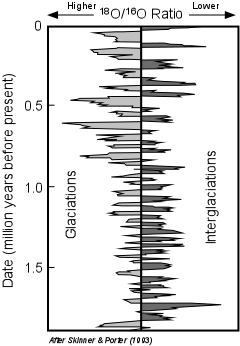
Thus, we expect that during glaciations the 18O / 16O ratio in seawater will be high, and during interglaciations the 18O / 16O ratio in seawater will be low.
Since organisms that live in the oceans extract Oxygen from seawater to form their carbonate (CO3-2) shells, measuring the 18O / 16O ratio in the shells of dead organisms gives a record of past ocean temperatures. The record for the past two million years is shown below and in figure 11.30 on page 332 of your text. This suggests about 30 glaciations separated by interglaciations during the past 2 million years.
During the last 1 million years it appears that each glacial - interglacial cycle has lasted about 100,000 years, but earlier cycles were about 40,000 years long.
Other periods of glaciation are known from the geologic record, mainly from preserved glacial striations and tillites (consolidated till). The earliest recognized glaciation occurred about 2.3 billion years ago, but at least 50 other glaciations are recognized to have occurred during the Paleozoic era.
Causes of Glacial Ages
In order to understand what causes these cycles of glacial - interglacial episodes we need a much better understanding of what causes global climate changes. Because human history is so short compared to the time scales on which global climate change occurs, we do not completely understand the causes. However, we can suggest a few reasons why climates fluctuate.
- Long term variations in climate (tens of millions of years) on a single continent are likely caused by drifting continents. If a continent drifts toward the equator, the climate will become warmer. If the continent drifts toward the poles, glaciations can occur on that continent.
- Short-term variations in climate are likely controlled by the amount of solar radiation reaching the Earth. Among these are astronomical factors and atmospheric factors.
Astronomical Factors -
- Variation in the eccentricity of the Earth's orbit around the sun has periods of about 400,0000 years and 100,000 years.
- Variation in the tilt of the Earth's axis has a period of about 41,000 years.
- Variation in the way the Earth wobbles on its axis, called precession, has a period of about 23,000 years.
- The combined effects of these astronomical variations results in periodicities similar to those observed for glacial - interglacial cycles.
Atmospheric Factors
- the composition of the Earth's atmosphere can be gleaned from air bubbles trapped in ice in the polar ice sheets. Studying drill core samples of such glacial ice and their contained air bubbles reveals the following:
During past glaciations, the amount of CO2 and methane, both greenhouse gasses that tend to cause global warming, were lower than during interglacial episodes.
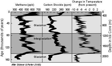
During past glaciations, the amount of dust in the atmosphere was higher than during interglacial periods, thus more heat was likely reflected from the Earth's atmosphere back into space.
The problem in unraveling what this means comes from not being able to understand if low greenhouse gas concentration and high dust content in the atmosphere caused the ice ages or if these conditions were caused by the ice ages.
Changes in Oceanic Circulation
- small changes in ocean circulation can amplify small changes in temperature variation produced by astronomical factors.
Other factors
- The energy output from the sun may fluctuate.
- Large explosive volcanic eruptions can add significant quantities of dust to the atmosphere reflecting solar radiation and resulting in global cooling.