El Niño and the Southern Oscillation Investigations

El Niño and the Southern Oscillation Investigation
© 2002 American Geological Institute. http://www.agiweb.org
Contents: All Activities and
Investigations
El Niño and the Southern Oscillation
Investigation
El Niño and the Southern Oscillation Investigation
Comparing tables and charts
by Kimberly Amaral Bob Henson Kevin E. Trenberth
For many years, coastal residents of Peru had noticed a strange feature of the eastern Pacific Ocean waters that border their home. This region of tropical yet relatively cool water is host to one of the world's most productive fisheries and a large bird population. In the first months of each year, a warm southward current usually modified the cool waters. But every few years, this warming started early (in December), was far stronger, and lasted as long as a year or two. Torrential rains fell on the arid land; as one early observer put it, "the desert becomes a garden." Warm waters flowing south brought water snakes, bananas, and coconuts from equatorial rain forests. However, the same current shut off the deeper, cooler waters that are crucial to sustaining the region's marine life.
This is El Niño, "the Christ child," so named because of its frequent late December appearance. Once thought to affect only a narrow strip of water off Peru, it is now recognized as a large-scale oceanic warming that affects most of the tropical Pacific. The meteorological effects related to El Niño and its counterpart, La Niña (a cooling of the eastern tropical Pacific), extend throughout the Pacific Rim to eastern Africa and beyond.
Flooding rains and warm weather in Peru wipe out the anchovy harvest. Torrential downpours and mud slides besiege southern California while the Northeast United States has fewer hurricanes and a mild winter. Droughts strike Indonesia, Africa, and Australia--all within the period of the same few months. Could all these events possibly be related?
Absolutely. In fact, it can happen about once every four to seven years--with varying intensity. And it all can be attributed to the same event: the El Niño/Southern Oscillation (ENSO).
El Niño (meaning "The Little One" in Spanish for its tendency to arrive around Christmas) is characterized by a dwindling, or sometimes even a reversal of trade winds. Normally the winds blow east to west across the southern Pacific. These winds travel along the surface of the sea and bring warm surface water along with them to the western coasts.
As the warm surface water is pushed away from the coasts of Peru, colder, nutrient-rich water rushes up to take its place. The result is some of the coolest water found in the lower latitudes (sometimes dipping to 68 degrees F), and a plentiful plankton-filled feeding ground for the anchovy population on which Peruvians count on for much of their economic survival. In the west, the warm water that's pushed along raises sea levels. By the time winds reach Micronesia, the sea level has risen about three feet and the water has warmed about seven degrees F.
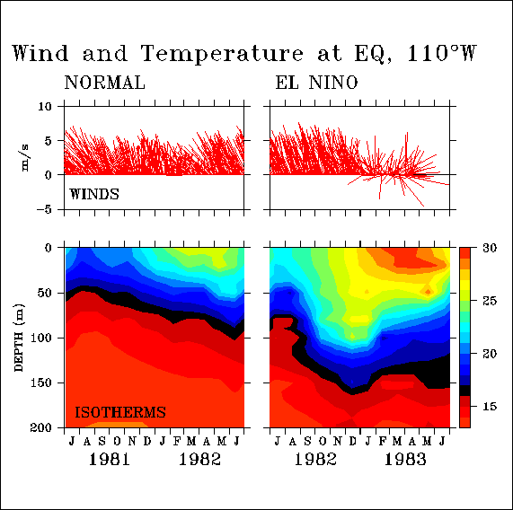
But during an El Niño, these trade winds relax, or even reverse, as was the case during the devastating 1982-1983 El Niño. Warm water sloshes back east in a vast, slow wave. Along the Peruvian coast, warm water builds up, driving the thermocline (the buffer zone between the upper layer of water and the frigid ocean below) down. The cooler, rich waters drop along with the thermocline, driving the anchovy population down with it, or killing off a large portion. (During the 1972 El Niño, the anchovy population dropped from 20 million to 2 million). This in turn reduces the number of marine birds who feed on the anchovy. The birds' excrement (guano) produces deposits on the islands off the Peru coast, which in the form of fertilizers is another important economic asset of Peru.
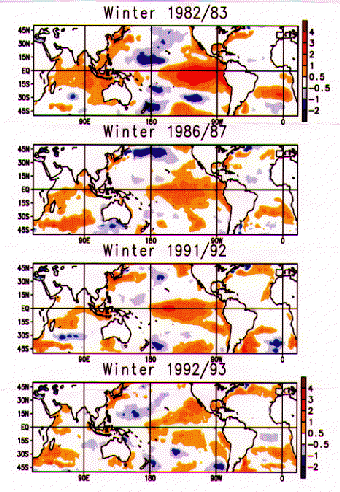
In these maps of four El Niño winters, the orange and red areas illustrate how much warmer (in degrees Celcius) sea surface temperatures were. Courtesy of the Center for Climate Analysis.
Since the turn of the century, scientists believed this phenomena occurred independently of any other weather patterns. But in the last few decades, they have learned that pressure changes and wind currents also play a vital role. Part of this deals with the Southern Oscillation.
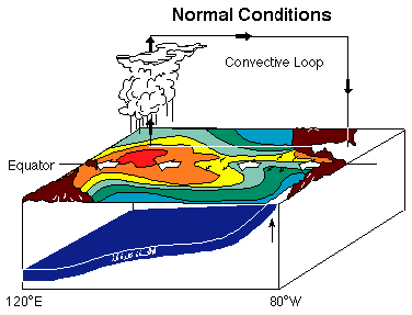
The Southern Oscillation is a seesaw of air pressures on the eastern and western halves of the Pacific. Normally the atmosphere above the eastern South Pacific is dominated by a persistent high-pressure zone, while a low pressure zone dominates the west. These two systems are coupled: when the pressure rises in the east, it falls in the west and vice versa. To measure this coupling, meteorologists take the pressure at Easter Island (about 2,700 miles west of South America), and subtract it from the pressure at Darwin in northern Australia. From this they calculate the southern oscillation index. This difference in pressures drives the trade winds from east to west along the equator under normal conditions. At the same time, high above the ocean surface, this wind circulation is completed, as it continues to blow around from west to east. This convection of air is called the Walker Circulation (named after Sir Gilbert Walker, who first identified it in the 1920s).
Illustrations of normal and El Niño conditions (above and below) from
"What is an El Niño?" Courtesy of the TAO Project at NOAA/Pacific Marine Environmental Laboratory.
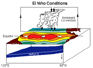
But every four to seven years, the southern oscillation index drops sharply. The east end of the pressure seesaw goes down, the west end goes up, and the Walker Circulation collapses and sometimes even reverses direction. With the collapse of the winds comes the characteristic warm flow of water to the east. All of these elements combined form the phenomena we call El Niño. A typical El Niño event lasts for 14-22 months; it decays when there is no longer enough warm water to sustain the cycle. There are, of course, exceptions to this: a wave of warm water from the 1982 El Niño--measuring only eight inches high in 1994 and traveling about five miles an hour--survived for 12 years.
El Niño is normally accompanied by a change in atmospheric circulation called the Southern Oscillation. Together, the ENSO (El Niño-Southern Oscillation) phenomenon is one of the main sources of interannual variability in weather and climate around the world. Since recognizing some 25 years ago that the oceanic and atmospheric parts of ENSO are strongly linked, scientists have moved steadily toward a deeper understanding of ENSO. Climate forecasters have taken the first steps toward predicting the onset of El Niño and La Niña events months in advance. Still, much remains to be learned about these children of the tropics.
It was the atmospheric part of ENSO-the Southern Oscillation, or SO-that first attracted the attention of scientists. Sir Gilbert Walker documented and named the SO in the 1930s. Other persistent patterns of high and low pressure had been previously noted in the North Pacific and North Atlantic; thus, the "southern" in SO.
The clearest sign of the SO is the inverse relationship between surface air pressure at two sites: Darwin, Australia, and the South Pacific island of Tahiti. High pressure at one site is almost always concurrent with low pressure at the other, and vice versa. The pattern reverses every few years. It represents a standing wave or "see-saw", a mass of air oscillating back and forth across the International Date Line in the tropics and subtropics.
This two-dimensional picture was extended vertically by renowned meteorologist Jacob Bjerknes in 1969. He noted that trade winds across the tropical Pacific flow from east to west. To complete the loop, he theorized, air must rise above the western Pacific, flow back east at high altitudes, then descend over the eastern Pacific. Bjerknes called this the Walker circulation (in honor of Sir Gilbert); he also was the first to recognize that it was intimately connected to the oceanic changes of El Niño and La Niña.
The persistent easterly trade winds are a key ingredient in the ENSO process. They have two major effects:
- Pushing water toward the western Pacific. The sea level in the Philippines is normally about 60 centimeters (23 inches) higher than the sea level on the southern coast of Panama.
- Allowing the westward-flowing water to remain near the surface and gradually heat. This gives the water's destination-the western Pacific-the warmest ocean surface on Earth. Usually above 28°C (82°F), parts of this pool are sometimes as warm as 31.5°C (89°F).
"It's a coupled ocean and atmosphere problem. The ocean is sensitive to the winds and the winds vary due to ocean temperatures," says John Toole, an associate scientist in physical oceanography at Woods Hole Oceanographic Institution in Massachusetts. Toole worked for several years on the Tropical Ocean and Global Atmosphere Programme (TOGA), a ten-year, international effort to understand tropical ocean and global atmosphere variability.
"I think the root cause of (El Niño) is buried in the ocean," says Toole. "The long time scale for El Niño is fundamentally linked to the width of the Pacific and the time it takes for that information to propagate across the Pacific...The Pacific tries to respond on an annual time scale (with the sun), but it can't because it's too wide." This, he says, causes anomalies like El Niño.
El Niño is not the only variation from the norm to occur in the Pacific. Sometimes, an anti-El Niño event will occur, where there is a cold phase along the eastern Pacific--also known as La Niña.
Like the rippling effect of a stone dropped in a pond, these events have also proven to have far-reaching global effects. El Niño events tend to dry out Australia and India while bringing heavy rains to the west coast of South and Central America. They also nudge the jet stream off course, supplying California with a more-than-healthy supply of rain, and suppressing Atlantic hurricanes. Scientists have also found a distinct correlation between the rise and fall of sea surface temperatures in the Pacific, and corn harvests in Zimbabwe. The link between the two is so tight, they could accurately predict Zibabwean harvests for the last 20 years using El Niño data for the previous year.
The effects of El Niño have even been felt as far south as Antarctica. More than 6,000 kilometers away, Weddell seals feel the brunt of ENSO events. James W. Testa of the University of Alaska in Fairbanks noticed that the number of births declines every four to six years--coinciding with ENSO events. He suggests that the seal declines may result from changes in the fish populations, caused possibly by shifts in ocean currents.
Much can be gained then, if El Niño could be predicted accurately. Peru, for instance, could anticipate a rainy season, and plant crops--like rice--adapted for the weather. So far, several scientists have been successful developing models to predict another El Niño onslaught.
As part of the TOGA study, scientists have developed computer models for predicting when the tropical Pacific will swing toward warm or cool temperatures. Ants Leetmaa of the Climate Analysis Center is developing a long-range forecasting strategy for the U.S. weather service. Using a tool called a coupled global circulation model, he similates how streams in the oceans and atmosphere shuttle heat and moisture around the planet. After plugging in the necessary data, the model spins through 270 simulated days. This model can predict sea surface temperatures over the next six months.
Mark Cane and Stephen Zebiak of Columbia University's Lamont-Doherty Geological Survey have developed a model they think can predict an El Niño event at least six months--and perhaps even a year--ahead of time. Cane and Zebiak first map out what goes into the making of an El Niño. They then plug in the essential elements: sea-surface temperatures and wind data, and estimate thermocline depth using information about surface winds. Their model correctly predicted El Niño events for three-fourths of the time over 15 years. And as for the remainder of their findings? They weren't exactly wrong--just cloudy.
Tim Barnett of the Scripps Institution of Oceanography in La Jolla, California has also developed an effective prediction model. His statistical approach looks for unusually high pressure moving eastward along the equator. After assembling 32 years of data on the western and eastern Pacific, his model correctly predicted the 1982 El Niño.