Global Positioning Systems

Global Positioning Systems
Global Positioning System (GPS)
What GPS Receivers Can Do
GPS satellites
Waypoints and Routes
Satellite Distribution
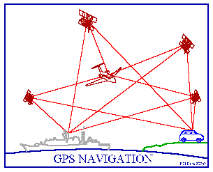
The Global Positioning System (GPS) is a collection of 24 earth-orbiting satellites. These satellites allow any person who owns a GPS receiver to determine his or her precise longitude, latitude and altitude anywhere on the planet. That is such an amazing capability!
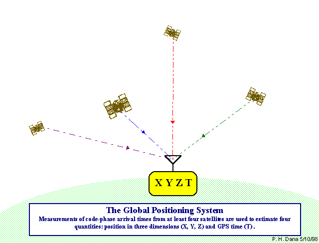
Four Satellites Triangulate to Locate Position
For as little as $250Aus you can know exactly where you are and where you have been. For anyone who has ever been lost while hiking in the woods, or lost in the middle of the ocean, or lost while driving in a unfamiliar city, or lost while flying a small airplane at night, a GPS receiver is a miracle. With a GPS, you are never lost. In this edition of How Stuff Works we will discuss both what a GPS receiver can do and how it works so that you can learn more about these amazing devices.
top...
What GPS Receivers Can Do
Here is a picture of a typical GPS receiver, in this case the Garmin GPS III:
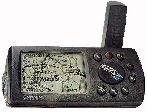
This is a handheld device weighing about 8 ounces and measuring about 6 inches by 12cm (ignoring the antenna). The antenna is the verical stub on the right, roughly three inches long. This unit has a small LCD screen and a set of buttons to activate its different features.
When you turn on a GPS receiver, its first task is to try to find the radio signals for the satellites it can "see".
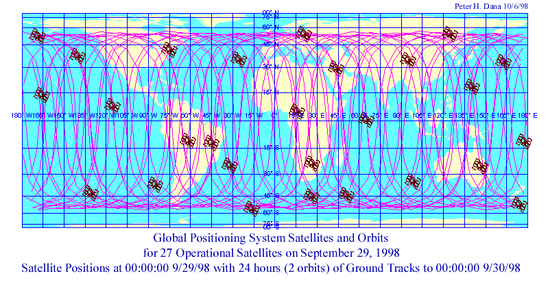
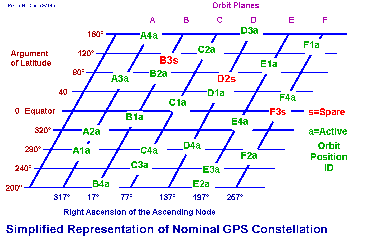
Orbit Map
GPS satellites
top...
GPS satellites live in very precise orbits about 16,000 km up (for comparison, the space shuttle orbits at about 320km and geosynchronous satellites orbit at about 38,600km). Because the satellites are so far away, their radio signals are fairly weak. Therefore, for the GPS receiver to "see" a satellite, the satellite must be above the horizon and unobstructed by buildings, mountains, etc. At any given moment at any point on the planet there are between 6 and 9 satellites above the horizon. During the process of acquiring the satellites, the GPS display will look something like this:
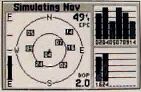
On this screen, the larger circle represents the horizon and smaller circle represents 45 degrees. The dot in the center is straight overhead. The numbers within the circles represent satellites that are visible, and the bar chart on the right represents the relative strength of the signals from the different satellites.
Once the GPS receiver has locked on to 3 satellites, it can display your longitude and latitude to about 100 foot accuracy. If the receiver can see 4 satellites it can also tell you your altitude. With this information you know exactly where you are.
Most modern GPS receivers are able to store your track. As you move, the GPS periodically stores your position in its internal memory. It can then show you the path you have followed on the display so that you can see exactly where you have been. Tacks also make backtracking easy.
top...
Waypoints and Routes
Most modern GPS receivers also support the concept of waypoints and routes. A waypoint is a specific point (longitude and latitude) that you have stored in memory. A route is a series of waypoints connected together to form a path from one point to another. You can imagine that if you are a boater, you might mark certain buoys as waypoints, or store the coordinates of your favorite fishing spots as waypoints. A hiker might store different landmarks or resting points along a trail as waypoints. You can then string a collection of waypoints together into a route. At the start of a trip you tell the GPS receiver which route you want to follow. The receiver will then tell you the heading you need to take to get to the next waypoint in the route. As you pass each waypoint, the GPS receiver gives you the heading to the next waypoint on the route.
Some of the newer receivers, like the GPS III shown above, have road maps stored in memory. The unit is therefore able to show you exactly where you are on a map of the area. Internal maps usually show major highways. By hooking a GPS up to a laptop computer you can locate yourself on very detailed road or topographic maps loaded from CD-ROMs. You can see from this description that GPS receivers help you to:
See exactly where you currently are
See exactly what path you have followed using tracks
Store and then get back to a place you have visited using waypoints
Get from point A to point B using waypoints and routes
GPS receivers are especially useful in environments where it is easy to get lost: on the ocean, in the woods, in the air flying at night, etc.
How the GPS System Works
Launched by the Department of Defense, the Global Positioning System became fully operational in 1994 with 24 satellites in orbit. The system has been functional much longer than that and was used, for example, in the gulf war in 1991.
The GPS system depends on two things to make it work: First, each satellite has an on-board atomic clock that gives it an extremely precise time base. The satellites send radio signals to the receiver, and the extremely precise time bases make it possible for the receiver to determine exactly how far away each satellite is.
Satellite Distribution
The receiver is able to calculate exactly how long it took for the signal to travel from the satellite to the receiver, and from that time determine the exact distance between the receiver and the satellite.
Second, each receiver has stored in memory an almanac that indicates exactly where each satellite is in its orbit at any given moment. The almanac is possible because of the extremely precise orbits flown by the satellites.
Since the receiver knows exactly where each satellite is (from the almanac) and exactly how far away each satellite is (from the radio signals it receives), the receiver can calculate its exact location in space. There are a couple of extremely interesting problems that have been glossed over here however. For example, a $250 hand-held GPS receiver certainly does not contain an atomic clock itself, so how does it synchronize itself with the satellites? It turns out that the radio signals sent by the satellites contain extra information that allows a receiver to derive the exact time from the radio signals it receives. The receiver must be able see multiple satellites for this algorithm to work, but what it means is that once a GPS receiver has locked on to 3 or more satellites, it is itself functioning with atomic clock accuracy. For more details on this trick and many others, see the first article in the Links section for an explanation.